Landsat Time-series Images-based Urban Heat Island Analysis: The Effects of Changes in Vegetation and Built-up Land on Land Surface Temperature in Summer in the Hanoi Metropolitan Area, Vietnam DOI: 10.32526/ennrj.18.2.2020.17
Article Sidebar
Main Article Content
Abstract
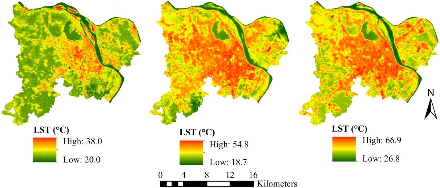
Rapid and unplanned urbanization leads to temperature rise, urban vegetation decrease and built-up land increase, forming an urban heat island (UHI). This study investigated the effects of changes in vegetation and built-up land on land surface temperature (LST) in summer, based on remotely sensed images. LST was first retrieved by means of the Radiative Transfer Model (RTM). Scatter-plots and an univariate linear regression model (ULRM) were first employed to independently measure the influence of NDVI on LST, and of NDBI on LST, respectively. In order to assess the effects of changes in vegetation and built-up land on LST, a multivariate linear regression model (MLRM) was finally employed to improve the accuracy of the predicted model in the identification of the joint effect of both the normalized difference vegetation index (NDVI) and the normalized difference built-up index (NDBI) on LST. The result from the case from the Hanoi Metropolitan Area (HMA), Vietnam using Landsat-5 TM and Landsat-8 OLI/TIRS time-series images during the 1996-2016 period shows that there exists a negative effect of built-up land and a positive effect of vegetation on LST. In addition, indications of intensifying UHI effects were detected in the HMA, especially tending to expand faster and wider to the parts of western, north-western and south-western HMA during the 1996-2007 period. These findings suggest that vegetation weakens the effect of UHIs, whereas, built-up land greatly strengthens the effect of UHIs in the HMA.
Article Details
Published articles are under the copyright of the Environment and Natural Resources Journal effective when the article is accepted for publication thus granting Environment and Natural Resources Journal all rights for the work so that both parties may be protected from the consequences of unauthorized use. Partially or totally publication of an article elsewhere is possible only after the consent from the editors.
References
2. Adler-Golden SM, Matthew MW, Bernstein LS, Levine RY, Berk A, Richtsmeier SC, et al. Atmospheric correction for shortwave spectral imagery based on MODTRAN4. Imaging Spectrometry V: International Society for Optics and Photonics 1999;3753:61-70.
3. Ahmadian N, Demattê J, Xu D, Borg E, Zölitz R. A new concept of soil line retrieval from Landsat 8 images for estimating plant biophysical parameters. Remote Sensing 2016;8(9):738-61.
4. Balling R, Brazel SW. High-resolution surface temperature patterns in a complex urban terrain. Photogrammetric Engineering and Remote Sensing 1988;54(9):1289-93.
5. Barsi JA, Barker JL, Schott JR. An atmospheric correction parameter calculator for a single thermal band earth-sensing instrument. Proceedings of the IEEE International Geoscience and Remote Sensing Symposium (IGARSS 2003); 2003 July 21-25; Toulouse: France; 2003.
6. Bokaie M, Zarkesh MK, Arasteh PD, Hosseini A. Assessment of urban heat island based on the relationship between land surface temperature and land use/land cover in Tehran. Sustainable Cities and Society 2016;23:94-104.
7. Chan HP, Chang CP, Dao PD. Geothermal anomaly mapping using landsat etm+ data in ilan plain, northeasten Taiwan. Pure and Applied Geophysics 2018;175(1):303-23.
8. Chander G, Markham BL, Helder DL. Summary of current radiometric calibration coefficients for Landsat MSS, TM, ETM+, and EO-1 ALI sensors. Remote Sensing of Environment 2009;113(5):893-903.
9. Dousset B, Gourmelon F. Satellite multi-sensor data analysis of urban surface temperatures and landcover. ISPRS Journal of Photogrammetry and Remote Sensing 2003;58(1-2):43-54.
10. Estoque RC, Murayama Y, Myint SW. Effects of landscape composition and pattern on land surface temperature: An urban heat island study in the megacities of Southeast Asia. Science of the Total Environment 2017;577:349-59.
11. Gallo K, McNab A, Karl TR, Brown JF, Hood J, Tarpley J. The use of NOAA AVHRR data for assessment of the urban heat island effect. Journal of Applied Meteorology 1993;32(5): 899-908.
12. Garcia O, Hemme T, Nho LT, Tra HTH. The Economics of Milk Production in Hanoi, Viet Nam, with Particular Emphasis on Small-Scale Producers. PPLPI Working Paper No. 33; 2006.
13. Goward SN, Xue Y, Czajkowski KP. Evaluating land surface moisture conditions from the remotely sensed temperature/vegetation index measurements: An exploration with the simplified simple biosphere model. Remote Sensing of Environment 2002;79(2-3):225-42.
14. Grossman DH, Faber-Langendoen D, Weakley AS, Anderson M, Bourgeron P, Crawford R, et al. International Classification of Ecological Communities: Terrestrial Vegetation of the United States. Volume I: The National Vegetation Classification System: Development, Status, and Applications. Virginia, USA: The Nature Conservancy; 1998.
15. Hiep NT. Economic evaluation of transportation infrastructure. Science 2014;47:415-55.
16. Hoang AH. Fractional vegetation cover estimation in urban area of Hanoi City using Landsat 8 OLI Images. VNU Journal of Science: Earth and Environmental Sciences 2016;32(3S): 101-8.
17. Hoang AH. Assessment of fractional vegetation cover changes in some urban and sub-urban areas of Hanoi using multi-spectral and multi-temporal Landsat Images. VNU Journal of Science: Earth and Environmental Sciences 2017;33(2):40-7.
18. Jensen JR. Remote Sensing of the Environment: An Earth Resource Perspective. Bengaluru, India: Pearson Education India; 2009.
19. Kikon N, Singh P, Singh SK, Vyas A. Assessment of urban heat islands (UHI) of Noida City, India using multi-temporal satellite data. Sustainable Cities and Society 2016;22:19-28.
20. Kumar D, Shekhar S. Statistical analysis of land surface temperature-vegetation indexes relationship through thermal remote sensing. Ecotoxicology and Environmental Safety 2015;121:39-44.
21. Lasko K, Vadrevu KP, Nguyen TTN. Analysis of air pollution over Hanoi, Vietnam using multi-satellite and MERRA reanalysis datasets. PloS One 2018;13(5):e0196629.
22. Liu L, Zhang Y. Urban heat island analysis using the Landsat TM data and ASTER data: A case study in Hong Kong. Remote Sensing 2011;3(7):1535-52.
23. Logan WS. The cultural role of capital cities: Hanoi and Hue, Vietnam. Pacific Affairs 2005;78(4):559-75.
24. Lu Y, Feng X, Xiao P, Shen C, Sun J. Urban heat island in summer of Nanjing based on TM data. 2009 Joint Urban Remote Sensing Event; 2009 May 20-22; Shanghai: China; 2009.
25. Nguyen DQ, Yamasue E, Okumura H, Ishihara KN. Use and disposal of large home electronic appliances in Vietnam. Journal of Material Cycles and Waste Management 2009;11(4):358-66.
26. Nguyen TM, Lin T-H, Chan H-P. The environmental effects of urban development in Hanoi, Vietnam from satellite and meteorological observations from 1999-2016. Sustainability 2019;11(6):1768-92.
27. Nguyen TT, Vu TD. Use of hot spot analysis to detect underground coal fires from Landsat-8 TIRS data: A case study in the Khanh Hoa coal field, north-east of Vietnam. Environment and Natural Resources Journal 2019;17(3):1-10.
28. Oke TR. The energetic basis of the urban heat island. Quarterly Journal of the Royal Meteorological Society 1982; 108(455):1-24.
29. Ongsomwang S, Dasananda S, Prasomsup W. Spatio-temporal urban heat island phenomena assessment using Landsat Imagery: A case study of Bangkok metropolitan and its vicinity, Thailand. Environment and Natural Resources Journal 2018;16(2):29-44.
30. Orhan O, Ekercin S, Dadaser-Celik F. Use of Landsat land surface temperature and vegetation indices for monitoring drought in the Salt Lake Basin Area, Turkey. The Scientific World Journal 2014;2014:1-11.
31. Ranagalage M, Estoque RC, Murayama Y. An urban heat island study of the Colombo metropolitan area, Sri Lanka, based on Landsat data (1997-2017). ISPRS International Journal of Geo-Information 2017;6(7):189-206.
32. Rhee J, Im J. Estimating high spatial resolution air temperature for regions with limited in situ data using MODIS products. Remote Sensing 2014;6(8):7360-78
33. Sanecharoen W, Nakhapakorn K, Mutchimwong A, Jirakajohnkool S, Onchang R. Assessment of urban heat island patterns in Bangkok metropolitan area using time-series of LANDSAT thermal infrared data. Environment and Natural Resources Journal 2019;17(4):87-102.
34. Sobrino JA, Jiménez-Muñoz JC, Sòria G, Romaguera M, Guanter L, Moreno J, et al. Land surface emissivity retrieval from different VNIR and TIR sensors. IEEE Transactions on Geoscience and Remote Sensing 2008;46(2):316-27.
35. Star JL, Estes, JE, McGwire KC, Arvidson RE, Rycroft MJ. Integration of Geographic Information Systems and Remote Sensing. New York, USA: Cambridge University Press; 1997.
36. Sun Q, Tan J, Xu Y. An ERDAS image processing method for retrieving LST and describing urban heat evolution: A case study in the Pearl River Delta Region in South China. Environmental Earth Sciences 2010;59(5):1047-55.
37. Tan J, Zheng Y, Tang X, Guo C, Li L, Song G, et al. The urban heat island and its impact on heat waves and human health in Shanghai. International Journal of Biometeorology 2010; 54(1):75-84.
38. Thanh Hoan N, Liou YA, Nguyen KA, Sharma R, Tran DP, Liou CL, et al. Assessing the effects of land-use types in surface urban heat islands for developing comfortable living in Hanoi City. Remote Sensing 2018;10(12):1965.
39. Tsunoda T, Cuong TC, Dong TD, Yen NT, Le NH, Phong TV, et al. Winter refuge for Aedes aegypti and Ae. albopictus mosquitoes in Hanoi during winter. PloS One 2014; 9(4):e95606.
40. Tuan VA, Shimizu T. Modeling of household motorcycle ownership behaviour in Hanoi City. Journal of the Eastern Asia Society for Transportation Studies 2005;6:1751-65.
41. Vu TD, Nguyen TT. Remote sensing and GIS-based river bank accretion/erosion assessment in the confluence of Thao-Da-Lo Rivers, North-East of Vietnam. EnvironmentAsia 2018a; 11(3):27-44.
42. Vu TD, Nguyen TT. Spatio-temporal changes of underground coal fires during 2008-2016 in Khanh Hoa coal field (North-east of Vietnam) using Landsat time-series data. Journal of Mountain Science 2018b;15(12):2703-20.
43. Weng Q. A remote sensing - GIS evaluation of urban expansion and its impact on surface temperature in the Zhujiang Delta, China. International Journal of Remote Sensing 2001; 22(10):1999-2014.
44. Weng Q, Lu D, Schubring J. Estimation of land surface temperature-vegetation abundance relationship for urban heat island studies. Remote Sensing of Environment 2004; 89(4):467-83.
45. Zanter K. Landsat 8 (L8) Data Users Handbook. California, USA: CreateSpace Independent Publishing Platform; 2016.
46. Zha Y, Gao J, Ni S. Use of normalized difference built-up index in automatically mapping urban areas from TM imagery. International Journal of Remote Sensing 2003;24(3):583-94.
47. Zhang Y, Odeh IO, Han C. Bi-temporal characterization of land surface temperature in relation to impervious surface area, NDVI and NDBI, using a sub-pixel image analysis. International Journal of Applied Earth Observation and Geoinformation 2009;11(4):256-64.