Glacial Lake Inventory Derived from Landsat 8 OLI in 2016–2018 in China–Pakistan Economic Corridor


Abstract
:1. Introduction
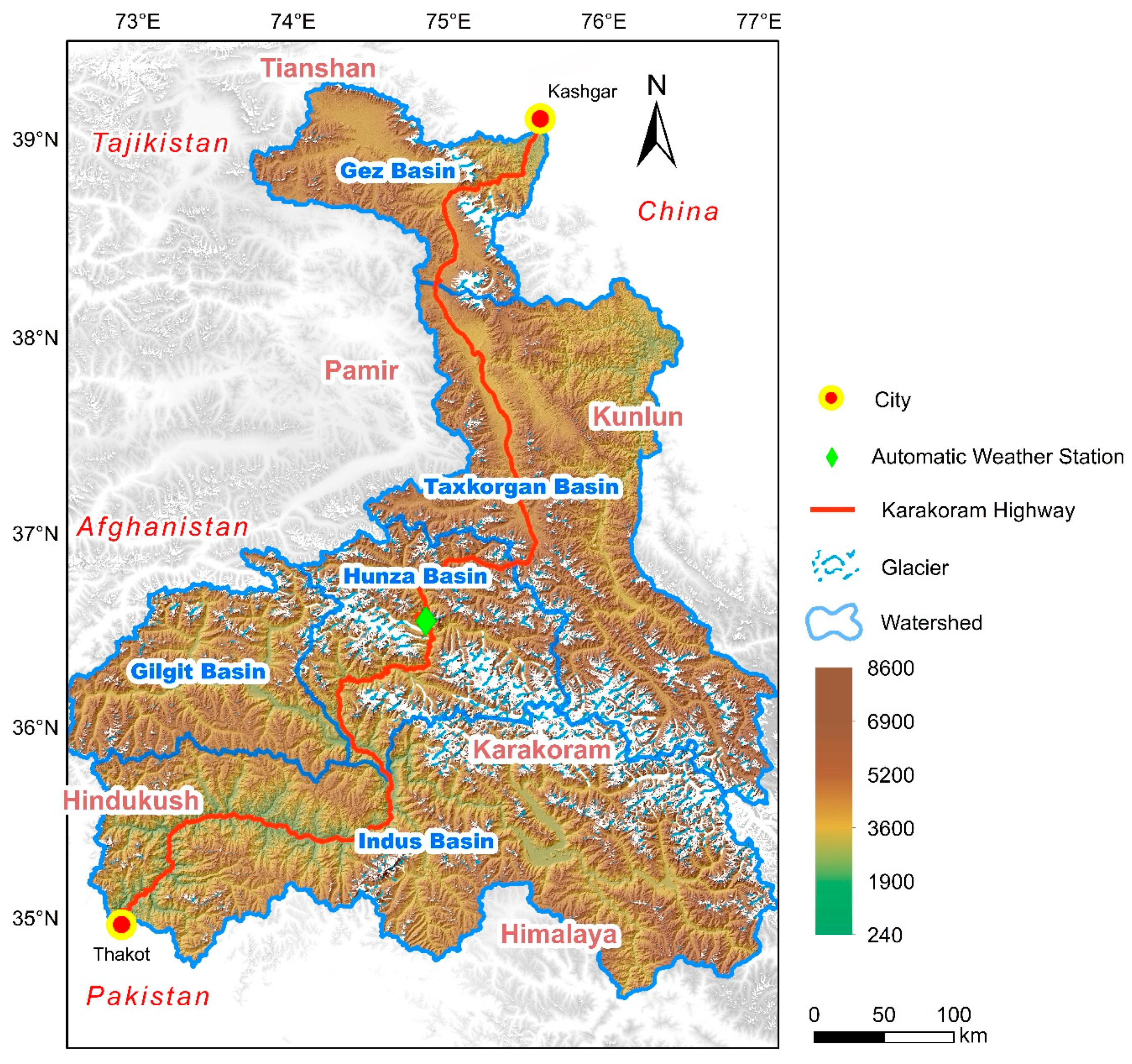
2. Study Region
3. Input Data
4. Methods
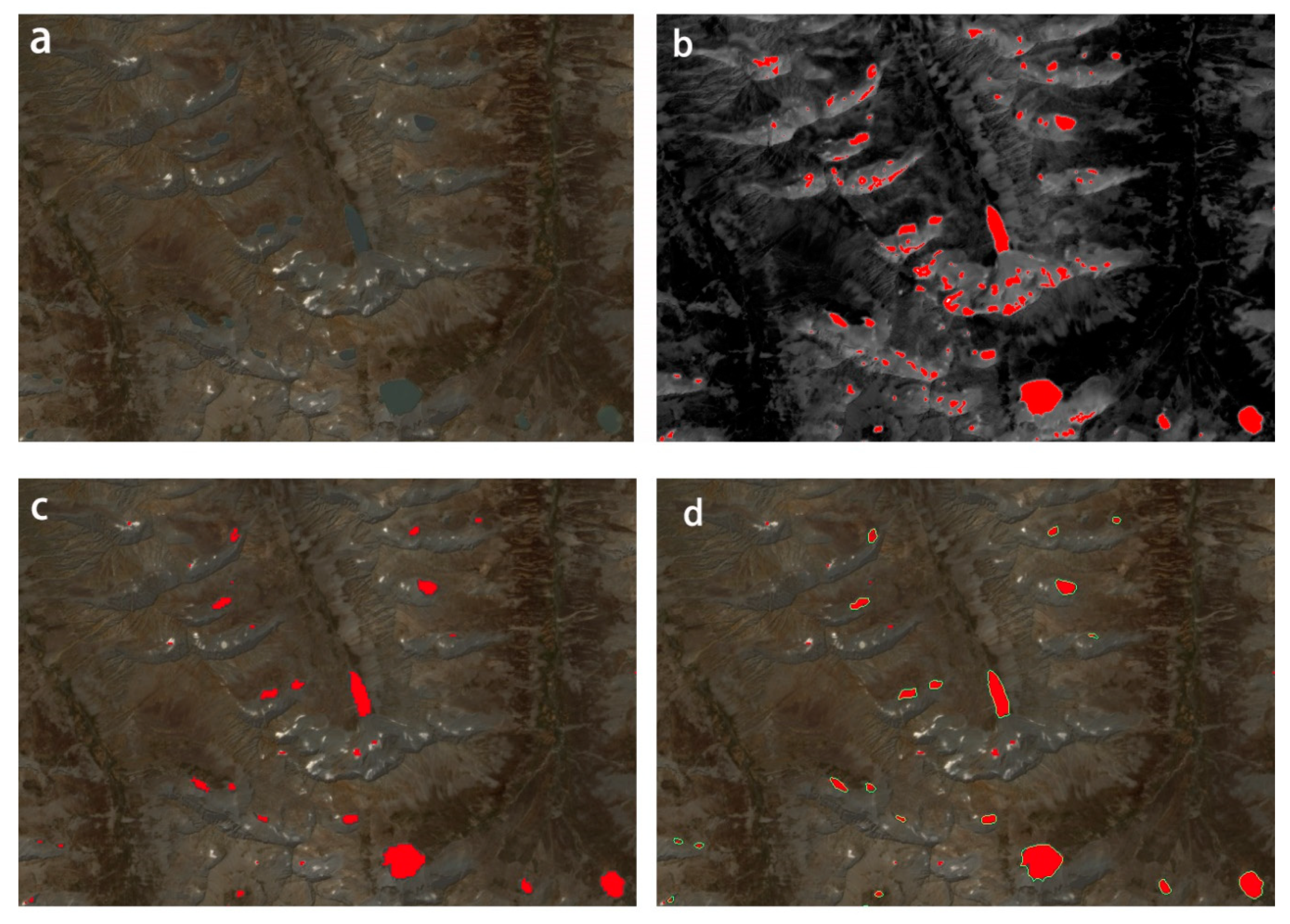
4.1. Glacial Lake Mapping
4.2. Glacial Lake Definition and Classification
4.3. Glacial Lake Coding
4.4. Uncertainty
5. Results
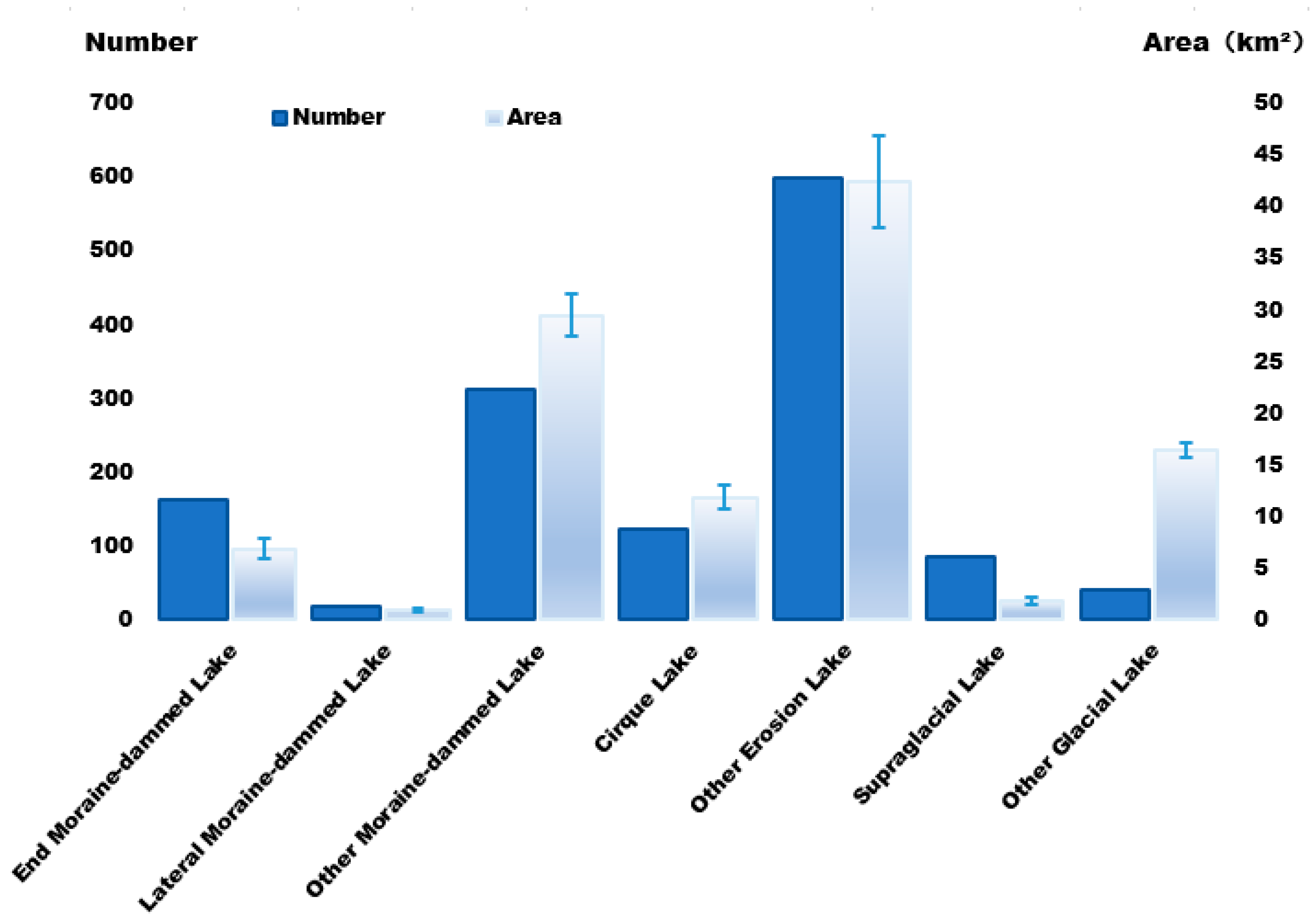
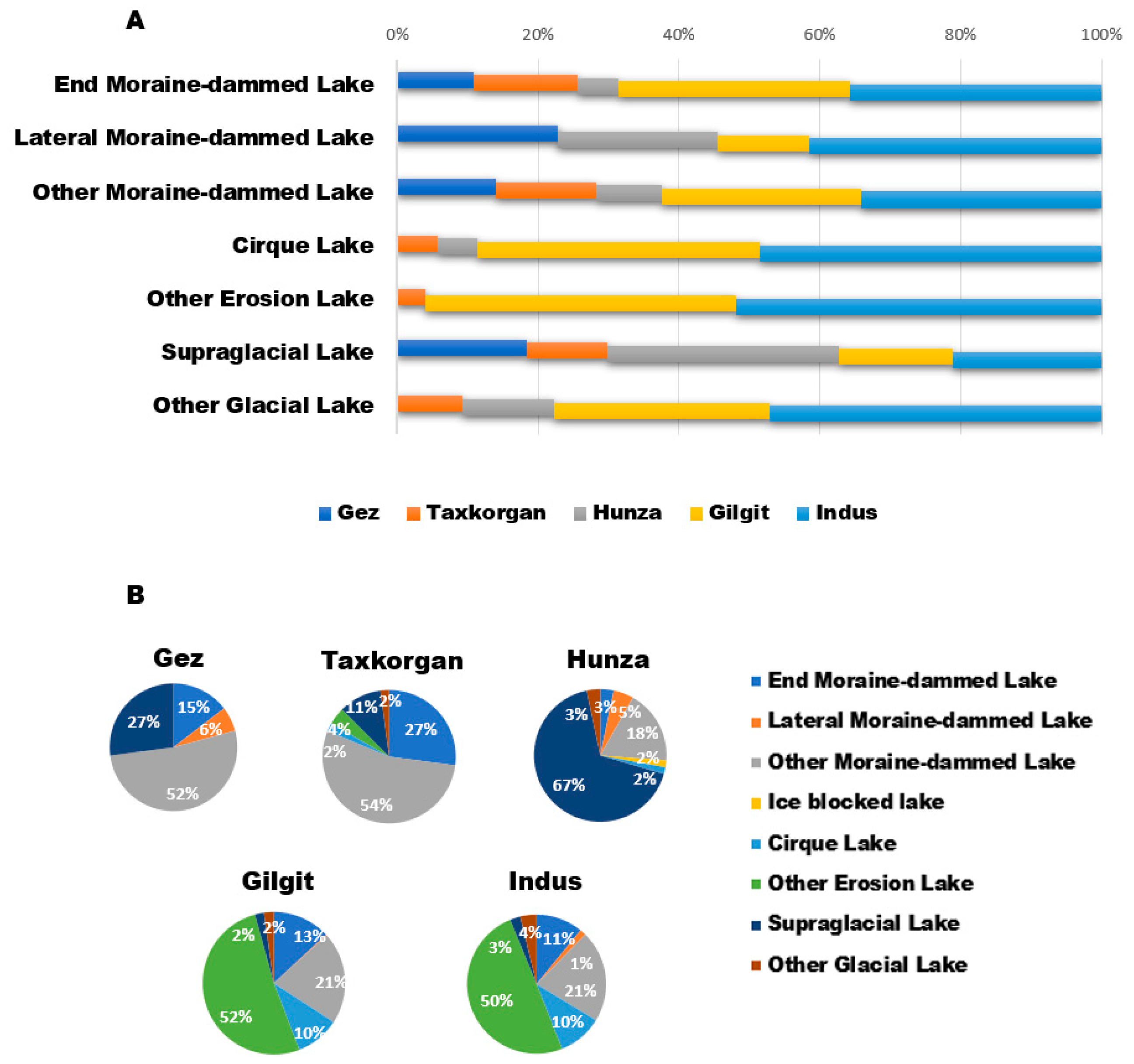
5.1. Number and Area of Glacial Lakes
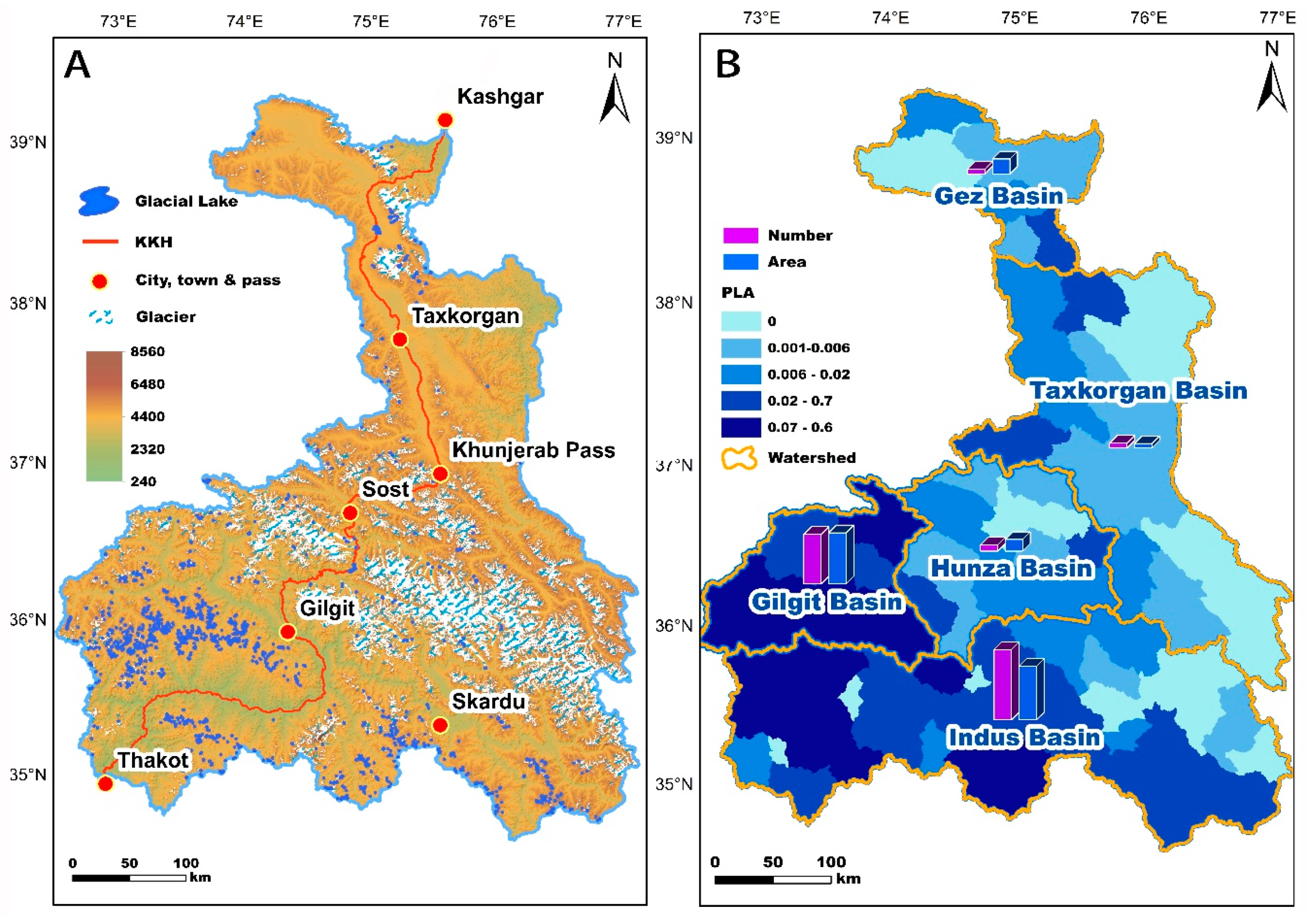
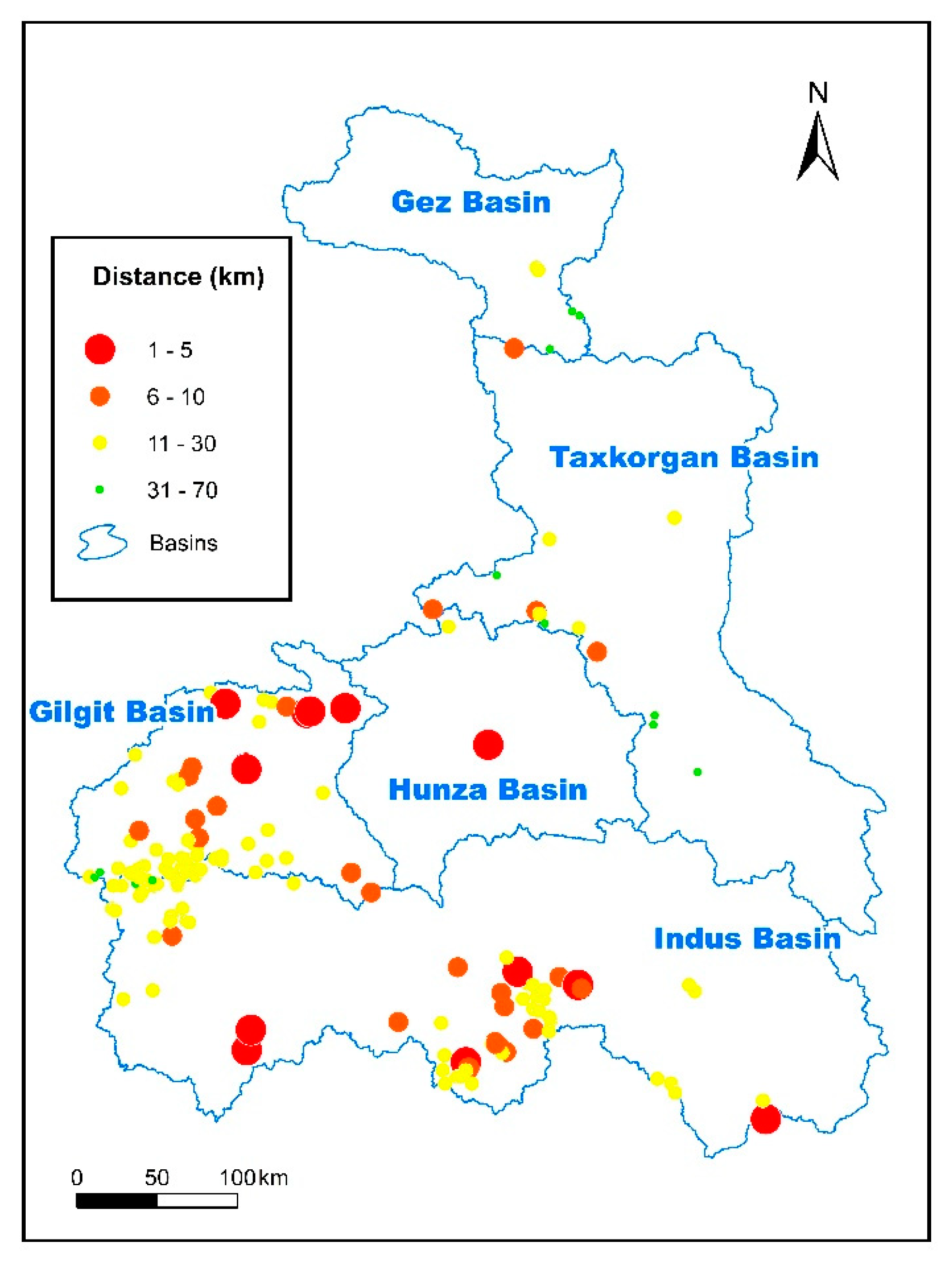
5.2. Spatial Distribution of Glacial Lakes in the CPEC
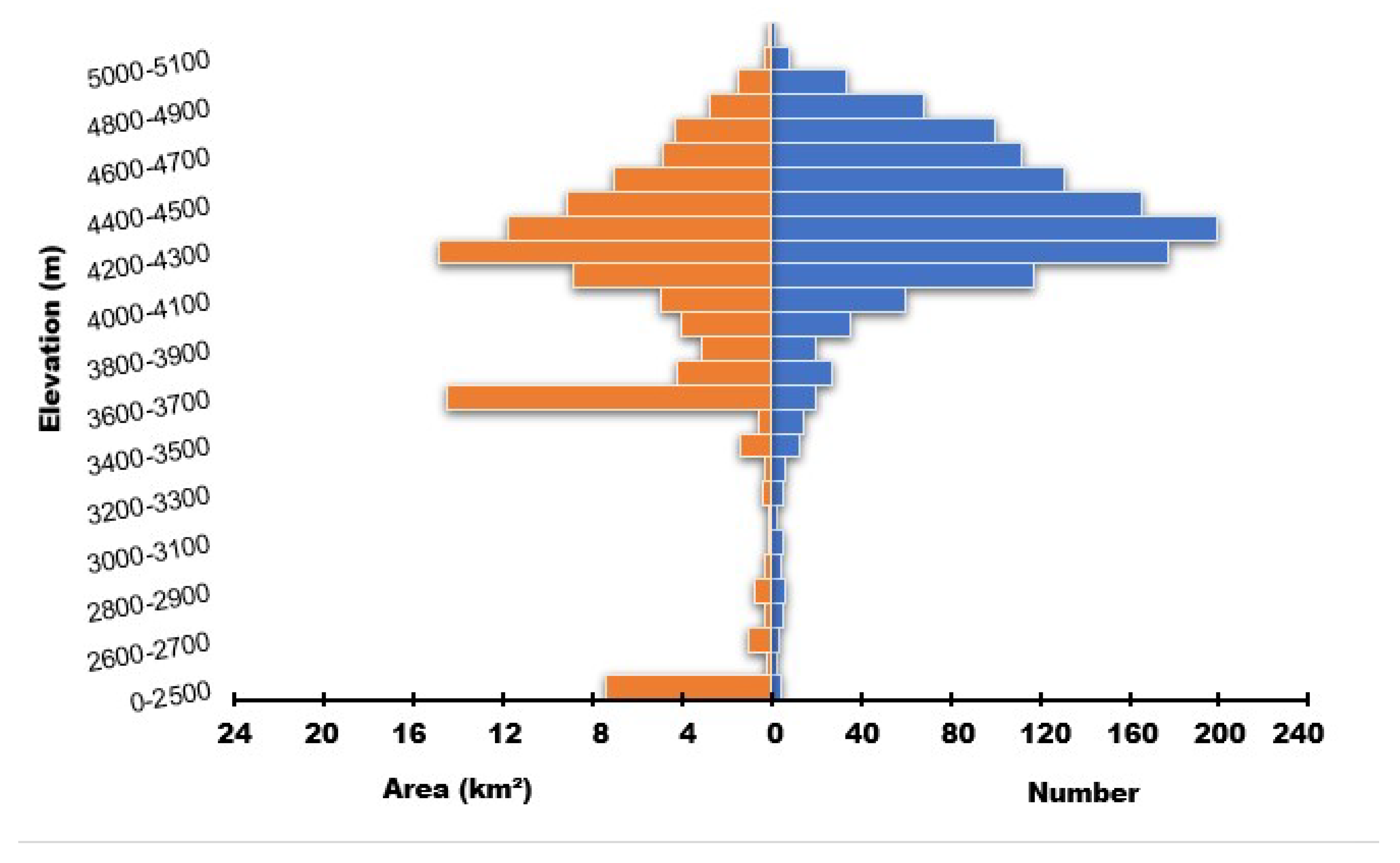
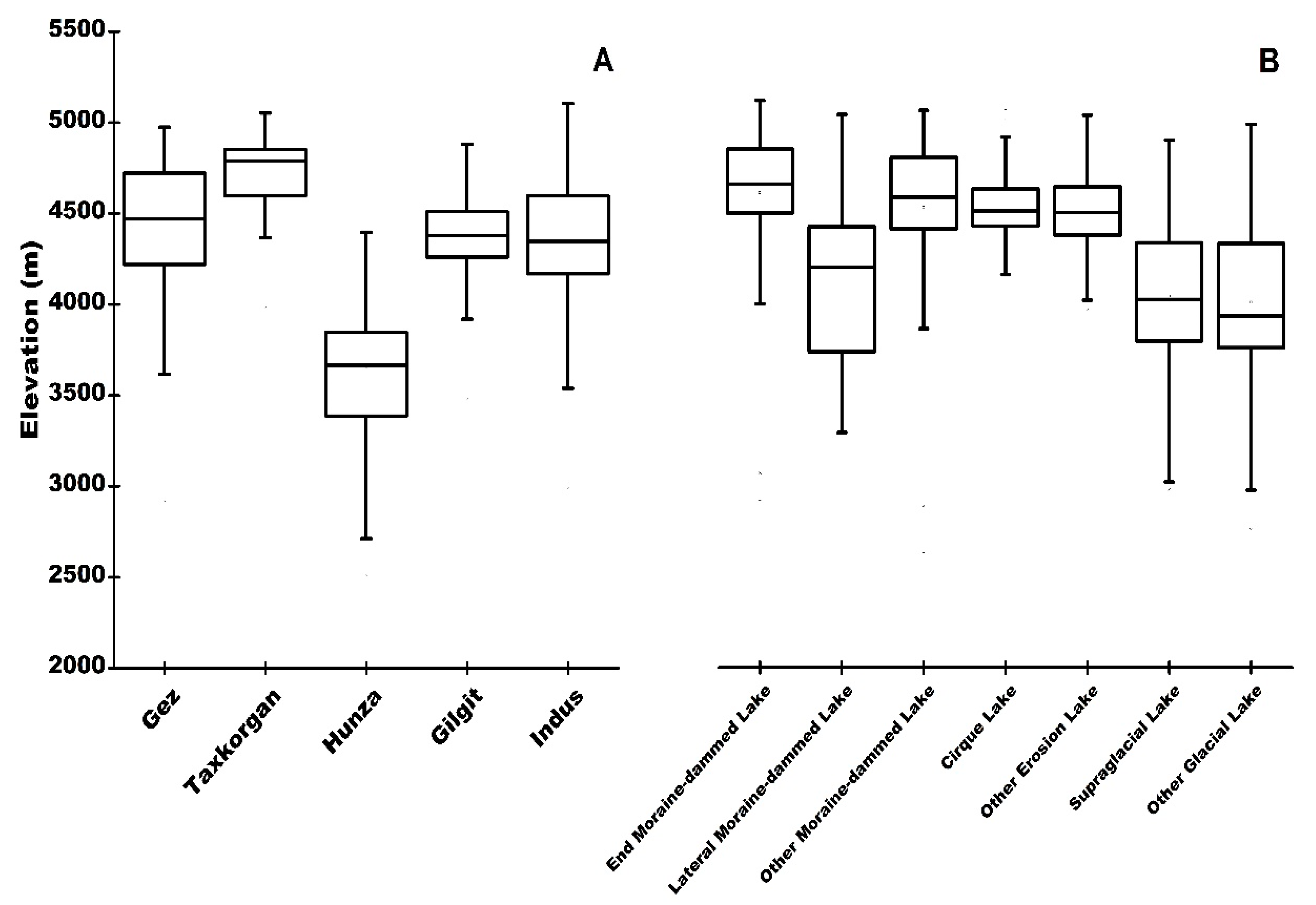
5.3. Distribution of Glacial Lakes by Elevation
5.4. GLOF Evaluation
6. Discussion
7. Conclusions
Supplementary Materials
Supplementary File 1Author Contributions
Funding
Acknowledgments
Conflicts of Interest
Data Availability
References
- Mool, P.K. Glacial lakes and glacial lake outburst floods in the Himalayas. Nepal Geol. Soc. 2010, 110, 19–21. [Google Scholar]
- Hewitt, K.; Liu, J. Ice-Dammed lakes and outburst floods, Karakoram Himalaya: Historical perspectives on emerging threats. Phys. Geogr. 2010, 31, 528–551. [Google Scholar] [CrossRef]
- Tariq, S.; Mahmood, A.; Rasul, G. Temperature and Precipitation: GLOF Triggering Indicators in Gilgit-Baltistan, Pakistan. Pakistan J. Meteorol. 2014, 10, 39–56. [Google Scholar]
- Song, C.; Sheng, Y. Contrasting evolution patterns between glacier-fed and non-glacier-fed lakes in the Tanggula Mountains and climate cause analysis. Clim. Change 2016, 135, 493–507. [Google Scholar] [CrossRef]
- Wang, X.; Siegert, F.; Zhou, A.-G.; Franke, J. Glacier and glacial lake changes and their relationship in the context of climate change, Central Tibetan Plateau 1972-2010. Glob. Planet. Change 2013, 111, 246–257. [Google Scholar] [CrossRef]
- Kääb, A.; Reynolds, J.; Haeberli, W. Glacier and Permafrost Hazards in High Mountains; Springer: Dordrecht, Netherlands, 2005. [Google Scholar]
- Nie, Y.; Liu, Q.; Liu, S. Glacial lake expansion in the Central Himalayas by landsat images, 1990-2010. PLoS ONE 2013, 8, e83973. [Google Scholar] [CrossRef] [Green Version]
- Allen, S.K.; Linsbauer, A.; Randhawa, S.S.; Huggel, C.; Rana, P.; Kumari, A. Glacial lake outburst flood risk in Himachal Pradesh, India: An integrative and anticipatory approach considering current and future threats. Nat. Hazards 2016, 84, 1741–1763. [Google Scholar] [CrossRef] [Green Version]
- Haritashya, U.K.; Kargel, J.S.; Shugar, D.H.; Leonard, G.J.; Strattman, K.; Watson, C.S.; Shean, D.; Harrison, S.; Mandli, K.T.; Regmi, D. Evolution and controls of large glacial lakes in the Nepal Himalaya. Remote Sens. 2018, 10, 798. [Google Scholar] [CrossRef] [Green Version]
- Zhang, G.; Yao, T.; Xie, H.; Wang, W.; Yang, W. An inventory of glacial lakes in the Third Pole region and their changes in response to global warming. Glob. Planet. Change 2015, 131, 148–157. [Google Scholar] [CrossRef]
- Song, C.; Sheng, Y.; Wang, J.; Ke, L.; Madson, A.; Nie, Y. Heterogeneous glacial lake changes and links of lake expansions to the rapid thinning of adjacent glacier termini in the Himalayas. Geomorphology 2017, 280, 30–38. [Google Scholar] [CrossRef] [Green Version]
- Khadka, N.; Zhang, G.; Thakuri, S. Glacial lakes in the Nepal Himalaya: Inventory and decadal dynamics (1977–2017). Remote Sens. 2018, 10, 1913. [Google Scholar] [CrossRef] [Green Version]
- Wang, X.; Ding, Y.; Liu, S.; Jiang, L.; Wu, K.; Jiang, Z.; Guo, W. Changes of glacial lakes and implications in Tian Shan, central Asia, based on remote sensing data from 1990 to 2010. Environ. Res. Lett. 2013, 8, 44–52. [Google Scholar] [CrossRef]
- Narama, C.; Duishonakunov, M.; Kääb, A.; Daiyrov, M.; Abdrakhmatov, K. The 24 July 2008 outburst flood at the western Zyndan glacier lake and recent regional changes in glacier lakes of the Teskey Ala-Too range, Tien Shan, Kyrgyzstan. Nat. Hazards Earth Syst. Sci. 2010, 10, 647–659. [Google Scholar] [CrossRef]
- Richardson, S.D.; Reynolds, J.M. An overview of glacial hazards in the Himalayas. Quat. Int. 2000, 65–66, 31–47. [Google Scholar] [CrossRef]
- Huggel, C.; Haeberli, W.; Kääb, A.; Bieri, D.; Richardson, S. An assessment procedure for glacial hazards in the Swiss Alps. Can. Geotech. J. 2004, 41, 1068–1083. [Google Scholar] [CrossRef]
- Gardelle, J.; Berthier, E.; Arnaud, Y.; Kääb, A. Region-wide glacier mass balances over the Pamir-Karakoram-Himalaya during 1999–2011. Cryosphere 2013, 7, 1263–1286. [Google Scholar] [CrossRef] [Green Version]
- Li, Y.; Ding, Y.; Shangguan, D.; Wang, R. Regional differences in global glacier retreat during climate warming from 1980 to 2015. Adv. Clim. Chang. Res. 2020. [Google Scholar] [CrossRef]
- Quincey, D.J.; Braun, M.; Glasser, N.F.; Bishop, M.P.; Hewitt, K.; Luckman, A. Karakoram glacier surge dynamics. Geophys. Res. Lett. 2011, 38. [Google Scholar] [CrossRef] [Green Version]
- Palazzi, E.; Von Hardenberg, J.; Provenzale, A. Precipitation in the hindu-kush karakoram himalaya: Observations and future scenarios. J. Geophys. Res. Atmos. 2013, 118, 85–100. [Google Scholar] [CrossRef]
- Kapnick, S.B.; Delworth, T.L.; Ashfaq, M.; Malyshev, S.; Milly, P.C.D. Snowfall less sensitive to warming in Karakoram than in Himalayas due to a unique seasonal cycle. Nat. Geosci. 2014, 7, 834–840. [Google Scholar] [CrossRef]
- Ahmad, I.; Zhang, F.; Tayyab, M.; Anjum, M.N.; Zaman, D.M.; Liu, J.; Farid, H.; Saddique, Q. Spatiotemporal analysis of precipitation variability in annual, seasonal and extreme values over upper Indus River basin. Atmos. Res. 2018, 213, 346–360. [Google Scholar] [CrossRef]
- Huggel, C.; Kääb, A.; Haeberli, W.; Teysseire, P.; Paul, F. Remote sensing based assessment of hazards from glacier lake outbursts: A case study in the Swiss Alps. Can. Geotech. J. 2002, 39, 316–330. [Google Scholar] [CrossRef] [Green Version]
- Mölg, N.; Bolch, T.; Rastner, P.; Strozzi, T.; Paul, F. A consistent glacier inventory for Karakoram and Pamir derived from Landsat data: Distribution of debris cover and mapping challenges. Earth Syst. Sci. Data 2018, 10, 1807–1827. [Google Scholar] [CrossRef] [Green Version]
- Nuimura, T.; Sakai, A.; Taniguchi, K.; Nagai, H.; Lamsal, D.; Tsutaki, S.; Kozawa, A.; Hoshina, Y.; Takenaka, S.; Omiya, S.; et al. The GAMDAM glacier inventory: A quality-controlled inventory of Asian glaciers. Cryosphere 2015, 9, 849–864. [Google Scholar] [CrossRef] [Green Version]
- McFeeters, S.K. The use of the Normalized Difference Water Index (NDWI) in the delineation of open water features. Int. J. Remote Sens. 1996, 17, 1425–1432. [Google Scholar] [CrossRef]
- Xu, H. Modification of normalised difference water index (NDWI) to enhance open water features in remotely sensed imagery. Int. J. Remote Sens. 2006, 27, 3025–3033. [Google Scholar] [CrossRef]
- Raj, K.B.G.; Kumar, K.V. Inventory of Glacial Lakes and its Evolution in Uttarakhand Himalaya Using Time Series Satellite Data. J. Indian Soc. Remote Sens. 2016, 44, 959–976. [Google Scholar] [CrossRef]
- Wang, X.; Guo, X.; Yang, C.; Liu, Q.; Wei, J.; Zhang, Y.; Liu, S.; Zhang, Y.; Jiang, Z.; Tang, Z. Glacial lake inventory of High Mountain Asia (1990–2018) derived from Landsat images. Earth Syst. Sci. Data Discuss. 2020, 1–23. [Google Scholar]
- Rounce, D.R.; Watson, C.S.; McKinney, D.C. Identification of hazard and risk for glacial lakes in the Nepal Himalaya using satellite imagery from 2000-2015. Remote Sens. 2017, 9, 654. [Google Scholar] [CrossRef] [Green Version]
- Derbyshire, E. The Karakoram and northwest Himalaya: Review and speculations. Quat. Res. 2000, 120, 147–157. [Google Scholar]
- Allen, S.; Frey, H.; Huggel, C. GAPHAZ 2017: Assessment of Glacier and Permafrost Hazards in Mountain Regions –Technical Guidance Document; Standing Group on Glacier and Permafrost Hazards in Mountains (GAPHAZ) of the International Association of Cryospheric Sciences (IACS) and the International Permafrost Association (IPA): Zurich, Switzerland; Lima, Peru, 2017. [Google Scholar]
- Yao, X.; Liu, S.; Han, L.; Sun, M.; Zhao, L. Definition and classification system of glacial lake for inventory and hazards study. J. Geogr. Sci. 2018, 28, 193–205. [Google Scholar] [CrossRef] [Green Version]
- Nie, Y.; Sheng, Y.; Liu, Q.; Liu, L.; Liu, S.; Zhang, Y.; Song, C. A regional-scale assessment of Himalayan glacial lake changes using satellite observations from 1990 to 2015. Remote Sens. Environ. 2017, 189, 1–13. [Google Scholar] [CrossRef] [Green Version]
- Wang, W.; Xiang, Y.; Gao, Y.; Lu, A.; Yao, T. Rapid expansion of glacial lakes caused by climate and glacier retreat in the Central Himalayas. Hydrol. Process. 2015, 29, 859–874. [Google Scholar] [CrossRef]
- Narama, C.; Daiyrov, M.; Tadono, T.; Yamamoto, M.; Kääb, A.; Morita, R.; Ukita, J. Seasonal drainage of supraglacial lakes on debris-covered glaciers in the Tien Shan Mountains, Central Asia. Geomorphology 2017, 286, 133–142. [Google Scholar] [CrossRef] [Green Version]
- Clague, J.J.; Evans, S.G. A review of catastrophic drainage of moraine-dammed lakes in British Columbia. Quat. Sci. Rev. 2000, 19, 1763–1783. [Google Scholar] [CrossRef]
- Granshaw, F.D.; Fountain, A.G. Glacier change (1958–1998) in the North Cascades National Park Complex, Washington, USA. J. Glaciol. 2006, 52, 251–256. [Google Scholar] [CrossRef] [Green Version]
- Hanshaw, M.N.; Bookhagen, B. Glacial areas, lake areas, and snow lines from 1975 to 2012: Status of the cordillera vilcanota, including the Quelccaya Ice Cap, northern central Andes, Peru. Cryosphere 2014, 8, 359–376. [Google Scholar] [CrossRef] [Green Version]
- Bolch, T.; Menounos, B.; Wheate, R. Landsat-based inventory of glaciers in western Canada, 1985-2005. Remote Sens. Environ. 2010, 114, 127–137. [Google Scholar] [CrossRef]
- Fujita, K.; Sakai, A.; Takenaka, S.; Nuimura, T.; Surazakov, A.B.; Sawagaki, T.; Yamanokuchi, T. Potential flood volume of Himalayan glacial lakes. Nat. Hazards Earth Syst. Sci. 2013, 13, 1827–1839. [Google Scholar] [CrossRef] [Green Version]
- Fujita, K.; Sakai, A.; Nuimura, T.; Yamaguchi, S.; Sharma, R.R. Recent changes in Imja Glacial Lake and its damming moraine in the Nepal Himalaya revealed by in situ surveys and multi-temporal ASTER imagery. Environ. Res. Lett. 2009, 4, 045205. [Google Scholar] [CrossRef]
- Allen, S.K.; Zhang, G.; Wang, W.; Yao, T.; Bolch, T. Potentially dangerous glacial lakes across the Tibetan Plateau revealed using a large-scale automated assessment approach. Sci. Bull. 2019, 64, 435–445. [Google Scholar] [CrossRef]
- Veh, G.; Korup, O.; von Specht, S.; Roessner, S.; Walz, A. Unchanged frequency of moraine-dammed glacial lake outburst floods in the Himalaya. Nat. Clim. Chang. 2019, 9, 379–383. [Google Scholar] [CrossRef]
- Butt, M.J.; Umar, M.; Qamar, R. Landslide dam and subsequent dam-break flood estimation using HEC-RAS model in Northern Pakistan. Nat. Hazards 2013, 65, 241–254. [Google Scholar] [CrossRef]
- Shah, A.; Ali, K.; Nizami, S.M.; Jan, I.U.; Hussain, I.; Begum, F. Risk assessment of shishper glacier, hassanabad hunza, north pakistan. J. Himal. Earth Sci. 2019, 52, 1–11. [Google Scholar]
- Rashid, I.; Majeed, U.; Jan, A.; Glasser, N.F. The January 2018 to September 2019 surge of Shisper Glacier, Pakistan, detected from remote sensing observations. Geomorphology 2020, 351, 106957. [Google Scholar] [CrossRef]
- Hewitt, K. Quaternary moraines vs. catastrophic rock avalanches in the Karakoram Himalaya, Northern Pakistan. Quat. Res. 1999, 51, 220–237. [Google Scholar] [CrossRef]
- Turnbull, J.M.; Davies, T.R.H. A mass movement origin for cirques. Earth Surf. Process. Landf. 2006, 31, 1129–1148. [Google Scholar] [CrossRef]


| Sensor | Path/Row | Date |
|---|---|---|
| Landsat 8 OLI | 148/35 | 2016/09/24 |
| 148/36 | 2017/10/29 | |
| 149/33 | 2018/07/19 | |
| 149/34 | 2016/10/01 | |
| 149/35 | 2016/10/01 | |
| 149/36 | 2017/10/04 | |
| 150/33 | 2017/09/09 | |
| 150/34 | 2017/09/09 | |
| 150/35 | 2017/09/09 | |
| 150/36 | 2017/10/27 | |
| 151/33 | 2018/07/17 | |
| 151/34 | 2016/10/15 | |
| 151/35 | 2016/10/15 | |
| 151/36 | 2016/10/15 |
| Lake Type | Definition | |
|---|---|---|
| Class | Subclass | |
| Blocked lakes | End moraine-dammed lakes | Lakes blocked by an end moraine; located in front of the mother glacier and supplied by the glacier |
| Lateral moraine-dammed lakes | Lakes blocked by lateral moraines located at both sides of the dam-forming glacier; its water supply is the dam-forming glacier | |
| Other moraine-dammed lakes | There are two other types of moraine-dammed lake: (1) lake developing on the moraine, mostly formed by the thawing of ice and typically situated on the end moraine of a modern glacier; and (2) lakes blocked by a moraine coming from a tributary valley glacier [37] | |
| Ice-blocked lakes | Lakes blocked by glacier ice; usually related to glacial advance | |
| Erosion lakes | Cirque lakes | Lakes located in a cirque and mainly caused by glacial retreat; typically supplied by a modern glacier but includes lakes located in an ancient cirque without a glacier |
| Other erosion lakes | Erosion lakes other than cirque lakes | |
| Supraglacial lakes | Lakes located on the surface of a glacier; caused by differential ablation of the glacier surface or affected by poor drainage of internal glaciers [36] | |
| Other glacial lakes | Lakes in glaciation areas; blocked by geological hazard such as landslide, rockfall, or debris flow [33] | |
| Lake Scale (km2) | Uncertainty (%) |
|---|---|
| 0.01–0.03 | 0.22 |
| 0.03–0.05 | 0.16 |
| 0.05–0.07 | 0.13 |
| 0.07–0.09 | 0.11 |
| 0.09–0.11 | 0.10 |
| 0.11–0.2 | 0.08 |
| 0.2–0.5 | 0.06 |
| 0.5– | 0.03 |
© 2020 by the authors. Licensee MDPI, Basel, Switzerland. This article is an open access article distributed under the terms and conditions of the Creative Commons Attribution (CC BY) license (http://creativecommons.org/licenses/by/4.0/).
Share and Cite
Li, D.; Shangguan, D.; Anjum, M.N. Glacial Lake Inventory Derived from Landsat 8 OLI in 2016–2018 in China–Pakistan Economic Corridor. ISPRS Int. J. Geo-Inf. 2020, 9, 294. https://0-doi-org.brum.beds.ac.uk/10.3390/ijgi9050294
Li D, Shangguan D, Anjum MN. Glacial Lake Inventory Derived from Landsat 8 OLI in 2016–2018 in China–Pakistan Economic Corridor. ISPRS International Journal of Geo-Information. 2020; 9(5):294. https://0-doi-org.brum.beds.ac.uk/10.3390/ijgi9050294
Chicago/Turabian StyleLi, Da, Donghui Shangguan, and Muhammad Naveed Anjum. 2020. "Glacial Lake Inventory Derived from Landsat 8 OLI in 2016–2018 in China–Pakistan Economic Corridor" ISPRS International Journal of Geo-Information 9, no. 5: 294. https://0-doi-org.brum.beds.ac.uk/10.3390/ijgi9050294