Next Article in Journal
Development of a New Daily-Scale Forest Fire Danger Forecasting System Using Remote Sensing Data
Previous Article in Journal
Estimation of Actual Crop Coefficients Using Remotely Sensed Vegetation Indices and Soil Water Balance Modelled Data
 
 
remotesensing-logo
Article Menu

Article Menu

Article

Development of Decadal (1985–1995–2005) Land Use and Land Cover Database for India

by
Parth S. Roy
1,*,†,
Arijit Roy
2,†,
Pawan K. Joshi
3,†,
Manish P. Kale
4,†,
Vijay K. Srivastava
5,†,
Sushil K. Srivastava
2,†,
Ravi S. Dwevidi
5,†,
Chitiz Joshi
2,†,
Mukunda D. Behera
6,†,
Prasanth Meiyappan
7,
Yeshu Sharma
1,
Atul K. Jain
7,*,
Jamuna S. Singh
8,
Yajnaseni Palchowdhuri
9,
Reshma. M. Ramachandran
1,
Bhavani Pinjarla
1,
V. Chakravarthi
1,
Nani Babu
10,
Mahalakshmi S. Gowsalya
11,
Praveen Thiruvengadam
11,
Mrinalni Kotteeswaran
11,
Vishnu Priya
12,
Krishna Murthy V. N. Yelishetty
2,
Sandeep Maithani
2,
Gautam Talukdar
13,
Indranil Mondal
13,
Krishnan S. Rajan
14,
Prasad S. Narendra
15,
Sushmita Biswal
3,
Anusheema Chakraborty
3,
Hitendra Padalia
2,
Manoj Chavan
4,
Satish N. Pardeshi
4,
Swapnil A. Chaudhari
4,
Arur Anand
16,
Anjana Vyas
9,
Mruthyunjaya K. Reddy
17,
M. Ramalingam
18,
R. Manonmani
18,
Pritiranjan Behera
6,
Pulakesh Das
6,
Poonam Tripathi
6,
Shafique Matin
6,
Mohammed L. Khan
19,
Om P. Tripathi
20,
Jyotihman Deka
20,
Prasanna Kumar
21 and
Deepak Kushwaha
1
add Show full author list remove Hide full author list
1
University Center for Earth and Space Science, University of Hyderabad, Prof. C R Rao Road, P.O. Central University, Hyderabad 500046, India
2
Indian Institute of Remote Sensing, ISRO, 4 Kalidas Road, Dehradun 248001, India
3
Department of Natural Resources, TERI University, Plot No. 10 Institutional Area, Vasant Kunj, New Delhi 110070, India
4
CDAC 3rd Floor, RMZ Westend Center 3, Westend IT Park, Nagras Road, Aundh, Pune 411007, India
5
National Remote Sensing Center, Balanagar, Hyderabad 500037, India
6
Indian Institute of Technology, Kharagpur 721302, India
7
Departments of Atmospheric Sciences, University of Illinois, Urbana-Champaign, 105 S South Gregory Street, Urbana, IL 61801, USA
8
Department of Botany, BHU, Varanasi 221005, India
9
CEPT University, Kasturbhai Lalbhai Campus, University Rd, Navrangpura, Ahmadabad, Gujarat 380009, India
10
SACI WATERS, B-87, 3rd Avenue, Sainikpuri, Secunderabad-500-094, Telangana, India
11
Anna University, Tirunelveli 627005, India
12
Anna University, Kotturpuram, Chennai 600025, India
13
Wildlife Institute of India, Chandrabani, Dehradun 248171, India
14
IIIT, Gachibouwli, Hyderabad 500032, India
15
SACON, Coimbatore 641108, India
16
RRSC-C, NRSC (ISRO), Amravati Road, Nagpur 440033, India
17
APSRAC, Chinthal Basthi, Hyderabad 500038, India
18
IRS Anna University, Chennai 600025, India
19
Dr. Harisingh Gour Central University, Sagar 470003, India
20
NERIST, National Highway 52A, Nirjuli, Arunachal Pradesh 791109, India
21
ORSAC, Plot No. 45/48, Jayadev Vihar, Bhubaneshwar 751023, India
*
Authors to whom correspondence should be addressed.
These authors contributed equally to this work.
Remote Sens. 2015, 7(3), 2401-2430; https://0-doi-org.brum.beds.ac.uk/10.3390/rs70302401
Submission received: 27 August 2014 / Revised: 30 January 2015 / Accepted: 6 February 2015 / Published: 27 February 2015

Abstract

:
India has experienced significant Land-Use and Land-Cover Change (LULCC) over the past few decades. In this context, careful observation and mapping of LULCC using satellite data of high to medium spatial resolution is crucial for understanding the long-term usage patterns of natural resources and facilitating sustainable management to plan, monitor and evaluate development. The present study utilizes the satellite images to generate national level LULC maps at decadal intervals for 1985, 1995 and 2005 using onscreen visual interpretation techniques with minimum mapping unit of 2.5 hectares. These maps follow the classification scheme of the International Geosphere Biosphere Programme (IGBP) to ensure compatibility with other global/regional LULC datasets for comparison and integration. Our LULC maps with more than 90% overall accuracy highlight the changes prominent at regional level, i.e., loss of forest cover in central and northeast India, increase of cropland area in Western India, growth of peri-urban area, and relative increase in plantations. We also found spatial correlation between the cropping area and precipitation, which in turn confirms the monsoon dependent agriculture system in the country. On comparison with the existing global LULC products (GlobCover and MODIS), it can be concluded that our dataset has captured the maximum cumulative patch diversity frequency indicating the detailed representation that can be attributed to the on-screen visual interpretation technique. Comparisons with global LULC products (GlobCover and MODIS) show that our dataset captures maximum landscape diversity, which is partly attributable to the on-screen visual interpretation techniques. We advocate the utility of this database for national and regional studies on land dynamics and climate change research. The database would be updated to 2015 as a continuing effort of this study.

Graphical Abstract

1. Introduction

Land-use and land-cover change (LULCC) is a key focus area for the global change community [1,2] because of its significant impacts on climate change [3], biogeochemical cycles [4], biodiversity [5], and water resources [6]. LULCC are driven by changes in multi-scale interacting driving factors such as biophysical conditions of the land, demography, technology, affluence, political structures, economy, and people’s attitudes and values [7]. These driving factors vary with geography and time; therefore, LULCC is also heterogeneous both spatially and temporally. Therefore, improved representation of both spatial and temporal dimensions of LULCC is crucial for better understanding human influence on the natural environment. One of the first steps towards this goal is to accurately quantify contemporary and historical LULCC, in a spatially explicit way. During the last 100 years, LULCC in India has been manifested in terms of agricultural expansion at the expense of forests [8]. This process continued until 1960s, when “Green Revolution”, for the first time, focused on enhancing agricultural production by means of new high-yielding varieties, extension of irrigation facilities, and use of fertilizers and pesticides [9]. Since the 1960s, modern economic development plans, and their implementation, nonetheless, set new trajectories and pace in the LULCC processes.
In this context, it is pertinent to mention that remote sensing offers an indispensable tool to monitor LULCC at regular time intervals. This technology can provide information on both biological (vegetation and its dynamics) and physical conditions (variations in terrain and morphological features) of LULCC. However, standard LULCC information generated from remote sensing data over the decades continues to be a challenging task, owing to the prevailing variations in spatial resolution of satellite data [10,11,12]. Numerous recent and on-going studies have improved both the measurements and understanding of factors influencing LULCC at the global scale, which in turn have paved the way to assimilate them in climate models [13,14,15,16,17]. However, at the same time it is observed that there is increased use of satellite remote sensing data has resulted in global, regional [2,3,17,18] and national initiatives to prepare land cover products [19,20,21,22,23,24,25,26,27,28,29]. Coarse resolution satellite data like NOAA-AVHRR, MODIS and SPOT-VGT with their high temporal resolution have been effectively used to provide repeatable land cover maps at regular intervals for LULCC [30,31]. On the other hand, LULC maps at medium to high resolution are limited/project specific and at times, are not available at regular intervals to study the long-term land cover dynamics in India [18,27,32,33,34]. While coarse resolution land cover products are a valuable resource for global scale assessments of LULCC, the national level assessments invariably require time-series products at much higher spatial resolution for two reasons. First, such products are required to map large scale LULC variability with accuracies more than 85% [31,35] for local governance. Second, the products should be able to delineate and estimate the areas of different cover types such as crop, forest, urban land, fallow land, wastelands, and water bodies. In diverse landscape regions like India, these features are characterized by small-scale fragmented zones having irregular shapes. As a result, such variability can be captured only by using medium and high-resolution satellite images. Moreover, medium-resolution LULC mapping is also crucial for supporting national level agricultural planning, biodiversity conservation, food-supply strategies, watershed development planning, and soil conversation initiatives.
The conventional approach to collect LULCC information in India at the national scale is through compilation of available records from the Directorate/Bureau of Economics and Statistics (DES/BES). Land use information derived from agricultural inventory of individual field plots is also available in nine-fold classification system comprising of land, irrigated area and total area under crops from different states and union territories of the country. In this study, we report for the first time the results of mapping LULCC for India at national scale at medium resolution (~30 m) for three decades (1985–1995–2005). The previous LULCC monitoring at regular intervals for India have been carried out at sub-national scales such as agro-climatic zones, biogeographic regions, meteorological sub-divisions, bioclimatic zones, and different watersheds [20,21,36,37]. National level LULCC mapping for India has received major impetus with the availability of multi-spectral and multi-resolution remote sensing data having synoptic and temporal coverage [19,20,21,22,23,26,27]. Table 1 summarizes the details of earlier initiatives taken by India over the last three decades for mapping and monitoring of LULCC using remote sensing data. These initiatives met the immediate national needs for planning and managing natural resources, agriculture expansion in the catchment, afforestation, eco-development, and preparation of watershed development and irrigation plans [36,37,38,39,40,41,42,43,44]. Most of these initiatives were one-time efforts and vary in terms of project objectives, classification schemes, methodology of mapping and the satellite data quality. In the present context, landscape dynamics and climate studies need information on phenology and leaf area index of forest; differentiation of cropland, fallow, barren and wasteland; mapping of non-permeable surface like built-up areas; and features like, dams, mining, aquaculture, and wetlands. To delineate these classes with acceptable accuracy, there is a need to use satellite data of high/medium spatial resolution. Besides, time-series maps should be consistent with internationally accepted land cover classification scheme so as to act as surrogate to climate variables.
Table 1. LULC mapping initiatives in India using satellite remote sensing.
Project/ProductData UsedScaleYearHighlights and References
Indian forest cover map Landsat MSS1:1M1972–1975 1982–1985Maiden effort to detect forest cover change. No spatial change [22]
Bi-Annual State of Forest ReportLandsat, IRS-LISS–III/LISS IV1:50K1987–till dateForest survey of India (FSI) uses satellite data of wet season to map tree cover of India (inside and outside forest areas) biannually [23]
Vegetation type and land coverMulti-temporal IRS-WiFS1:500K1998Mapping of major vegetation types of India using phenological investigations as a discriminant [24]
Biome level classification IRS-WiFS and climate database1:500K1998Mapping of major biomes of India using phenology from multi-date WiFS and subsequent spatial modeling using biophysical parameters [25]
Vegetation type and land coverIRS-LISS III1:50K2005–2006Vegetation type mapping of India using seasonal images, climate data, topographic variations and field sample data as part of Biodiversity characterization project [26,27]
LULC map (annually)IRS-AWiFS1:250K2004–till dateMapping major LULCC from multidate AWiFS data using hierarchical data mining. Focus was on to identify three cropping seasons for estimating net sown area [28]
LULC map IRS-LISS-III1:50K2005–2006 Level III LULCC maps of India prepared using three season multispectral data [29]
Here, we have generated time-series maps for three decades adopting the hierarchical International Geosphere-Biosphere Programme (IGBP) classification scheme [45]. We have extensively validated the LULC maps using ground truth data, existing maps, and very high-resolution satellite images available on the Google Earth. The study brings out the development of medium-resolution temporal LULC datasets of India using visual interpretation of multi-spectral satellite-based remote sensing data.

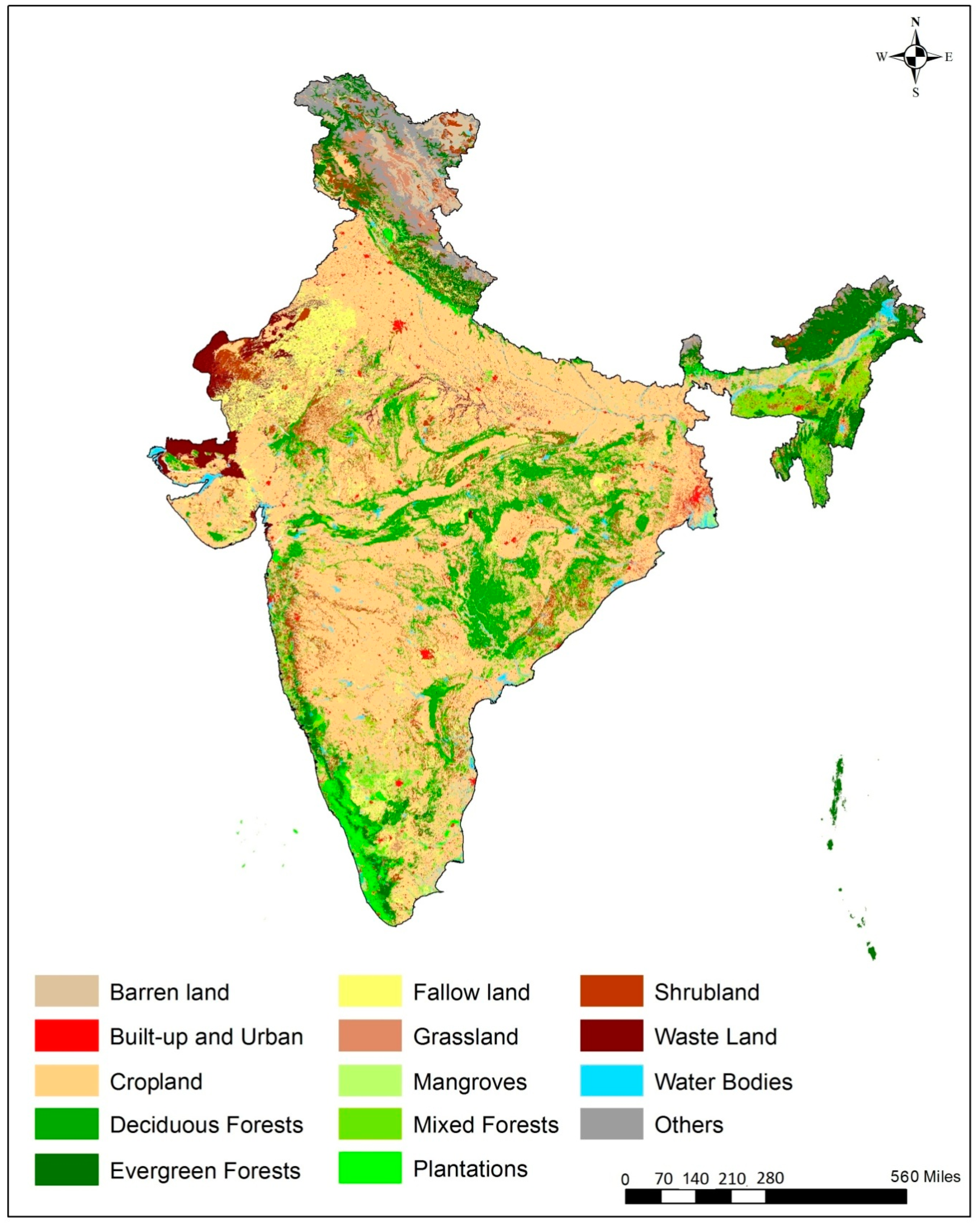
2. Results and Discussion

Land use and land cover maps from three different decades (1985, 1995 and 2005) have been prepared using three seasons’ satellite remote sensing data, vegetation type information and extensive ground truth. The visual interpretation has been carried out using on screen digitization. The flow chart of the approach is shown in Figure 1. The comprehensive satellite data, ground truth surveys, supplementary information and toposheets have been used to prepare the 2005 LULC map (Figure 2), which was subsequently used as a reference to prepare 1995 and 1985 LULC maps (Figures S1 and S2). Our analysis shows that the LULC in India has undergone important changes between 1985 and 2005 (Table 2 and Figure 3 and Figure 4). The total area that has changed during 1985–2005 is 0.10% of the total geographic area of the country (~340,932 km2). During this period, there has been a continuous decrease in land cover in the form of forests with concomitant increase in cropland and built-up area. Between 1985 and 2005, of the 11 major LULC classes, a considerable increase has been recorded in agriculture (47.55%–49.34%) and built-up areas (1.03%–1.44%), whereas significant decrease was noticed for forests (23.25%–22.18%), and wastelands (2.57%–2.27%). Within different forest classes, areas under mixed forest, savannah/woodlands/scattered trees, and mangroves have shown marginal increase. All the other forest classes remained either unchanged or declined marginally. Other LULC classes including barren land (2.00%–2.13%), plantations (2.36%–2.38%), and shrub land (5.56%–5.65%) also recorded marginal changes in their areas. Grassland remained unchanged, whereas marginal increase in shrub land area was noticed (Table 2).
Figure 1. Flow diagram of land use and land cover (LULC) Level-II (IGBP Classification) Mapping using multi-season geometrically co-registered satellite images Satellite images.
Remotesensing 07 02401 g001
Figure 2. Land use and land cover map of India for 2005. This map serves as a reference for 1995 and 1985 LULC maps (shown in supplementary).
Remotesensing 07 02401 g002
Figure 3. Land-use and land-cover changes in north western India over two decades (1985–2005). (A). Increase in the built up areas at the expense of agricultural areas in the Punjab plains. (B). Increase in the built up areas of Delhi and decrease of the land under agriculture and increase in fallow land in the regions of Haryana and Rajasthan. (C). Decrease in the vegetation cover in the Bundelkhand region mainly due to fragmentation.
Remotesensing 07 02401 g003
Figure 4. Land-use and land-cover changes in south India over the two decades (1985–2005). (A) Decrease in the vegetation cover to agriculture in Maharashtra and Madhya Pradesh. (B) Increase in the built up around major cities particularly Hyderabad over the two decades mainly at the expense of the wasteland and barren land. (C) Decrease in forest cover and Wasteland and increase in cropland in the Cauvery river basin.
Remotesensing 07 02401 g004
Table 2. Overall extent of land use and land cover classes in India.
Land Use/Land Cover ClassesArea
km2%
198519952005198519952005
Built-up and Urban34,01940,09047,2391.031.221.44
Cropland1,558,7121,556,3461,614,92147.5547.4549.34
Fallow land252,073266,671221,1367.688.136.77
Forest764,143745,173729,26223.2522.6722.18
-Deciduous broad leaf forest264,071241,647224,1018.037.356.82
-Deciduous needle leaf forest53,35853,13056,5831.621.621.62
-Evergreen broad leaf forest187,749185,083178,6465.715.635.43
-Evergreen needle leaf forest20,31420,07719,3460.620.610.59
-Mixed forest150,163149,523147,2844.574.554.48
-Mangrove4120452545790.130.140.14
-Savannah/woodlands/scattered Trees84,36891,18898,7232.572.773.01
Plantations77,49377,95678,5602.362.372.38
Shrub land182,860188,342192,8735.565.635.65
Grass land54,55356,60461,5951.661.621.66
Barren land65,48471,25069,8552.002.172.13
Waste land84,41478,64974,3552.572.402.27
Water bodies 1116,119121,148114,8563.553.693.50
Others 297,15291,63692,5222.962.792.82
Notes: 1 Includes Aqua Culture, Water bodies, and Permanent Wetlands; 2 Includes Salt Pan, Snow and Ice.
Furthermore, a steady decrease in forest area was recorded in both central India and parts of northeast India between 1985 and 2005 (Figure 3, Figure 4, Figure 5 and Figure 6). The areas under mangroves show a considerable increase during 1985–1995 and nominal increase during 1995–2005 due to various coastal protection legislations/ordinances formulated by the Government of India. The total area under cropland decreased during 1985–1995 and subsequently increased during 1995–2005 (Table 2). Cropland increase has been observed in the catchment areas of Narmada basin in Central India, Indira Gandhi Canal in Rajasthan and also in parts of Tamil Nadu in southern India (Figure 4). It was also noticed that in 1995, there was higher percentage of fallow and barren land as compared to 1985 and 2005 (Table 2). Besides receiving adequate rainfall during 1995 and 2005, the reason for enhanced agriculture activity could be due to the creation of canal irrigation (under Augmented Irrigation Benefit Programme) and construction of minor/mini irrigation tanks. In addition, a significant increase in plantation is noticed in the peninsular India and western Himalaya (Figure 7). It shows the success of state sponsored programs to meet the resource demand as well as to increase the green cover as per the national forest policy. These plantations are being carried out in forest gaps, wastelands, and on agriculture fields under agro-forestry programs.
Figure 5. Landscape of North Eastern India presents dominance of forests and shifting cultivation. (A) Decrease in forest cover types in Assam valley and Garo hills due to felling and shifting cultivation and (B) Decrease in area under evergreen forests and increase in cropland areas in Manipur.
Remotesensing 07 02401 g005
Figure 6. Loss of forest cover in central India during 1985–2005.
Remotesensing 07 02401 g006
Figure 7. Increase in crop land during 1985 to 2005 in western India and east coast of south India.
Remotesensing 07 02401 g007
Another substantial change in the land use over the decade is the steady increase in built-up area of about 13,219 km2 at the expense of the agricultural land (Table 2). The built-up area has increased by 6000–7000 km2 in each decade of the study period. The geographical built-up area has increased from 1.03% in 1985 to 1.22% in 1995 and then to 1.44% in 2005. The changes between 1995 and 2005 are more prominent than the period between 1985 and 1995. The increase in built-up area between 1995 and 2005 is more prominently observed in the north-western plains and in the peninsular India (Figure 3 and Figure 8). Studies on decadal datasets reveal that the built-up area has grown both in circular (radial growth of metropolitan cities) and linear patterns (settlements along the roads). In short, the present study provides important information to assess the changes in urban areas in terms of their spatial dimension and growth [46,47,48]. The maximum expansion in built-up area is observed around Delhi followed by Surat, Hyderabad, Bangalore, Kolkata, and Mumbai. The emergent urban agglomerations during the study period are Jaipur, Allahabad, Kanpur, Lucknow and Pune. However, the fastest growing urban areas in India are the medium sized settlements at the cost of agriculture land (Figure 3). Furthermore, Western Ghats and Western Himalayas have shown significant increase in plantations from 1985 to 1995 (Figure 9), beyond which no significant changes are noticed.
Figure 8. Map showing the urban growth during 1985–1995–2005. Major urban growth centers in north-west Punjab, western India around Mumbai region and Southern India are also shown.
Remotesensing 07 02401 g008
Figure 9. Significant changes in plantation area in Peninsular India and Western Himalaya during 1985–2005.
Remotesensing 07 02401 g009

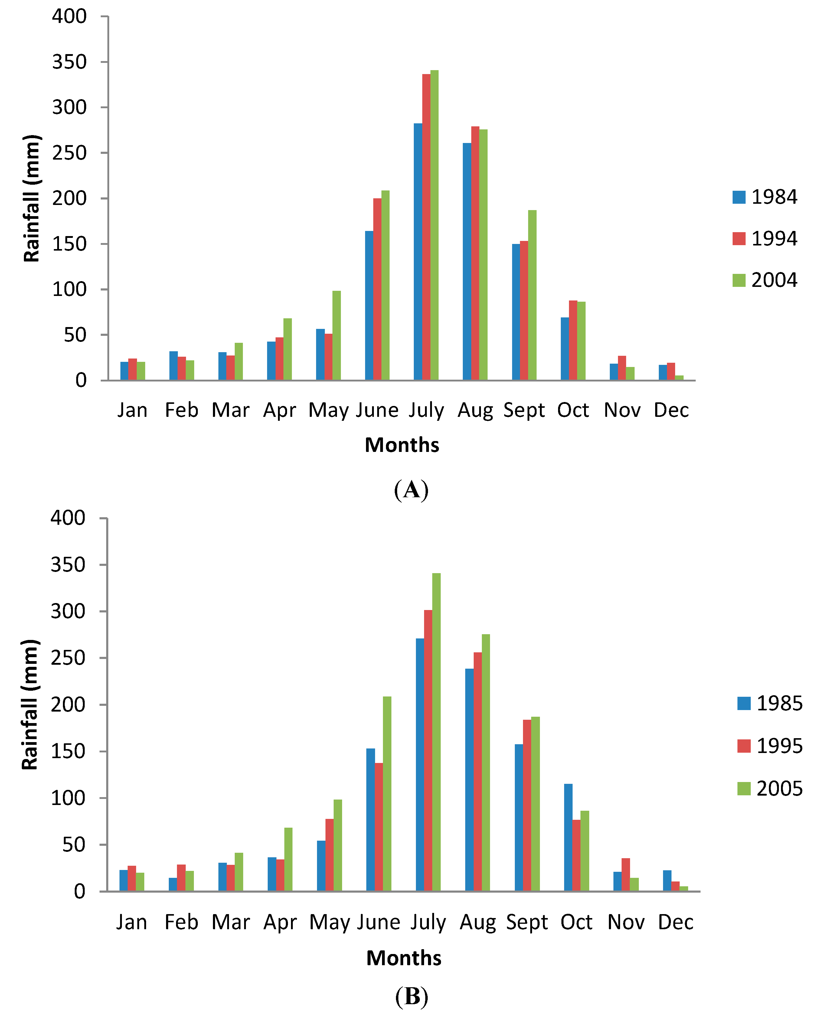
2.1. Accuracy Evaluation and Consistency between Decadal Trends

We evaluated the accuracy of LULC 2005 map using pre-determined field sample points. We have selected a total of 12,606 stratified random samples to assess the accuracy of the map with the help of ground truth data [26,27]. The above sample points were collected for the project on Biodiversity Characterization project of Indian Space Research Organization (ISRO) and Department of Biotechnology (DBT) [27]. We have used the confusion error matrix created with the mapped and ground reference points to determine the users’ accuracy and Cohen’s kappa accuracy (Table 3). Most of the LULC classes showed accuracies of more than 90% except for plantation, wasteland, and barren land. However, the accuracies of these three later classes are also within the acceptable limits (Table 3). We achieved an overall mapping accuracy of 94.46% and the Kappa accuracy of 0.9445 for 2005. The migration of classes (LULC change) from one category to another between different years (1985 to 2005) of mapping was found to be only 10.36% of total geographical area, of which it was 5.74% between 1985 and 1995, and 8.55% between 1995 and 2005. Out the changed areas, 5% geographical area between two time periods was verified on the ground using existing land and revenue records to ensure classification accuracy. It can be assumed that the mapping and Kappa accuracies of the 1995 and 1985 maps are similar to that of 2005.
Table 3. Land use/land cover (LULC) classification scheme and description of classes.
S. No.Land Cover Type (Level I) Land Use Type (IGBP Classification) (Level II)Description of Level II classes
1Built up/UrbanBuilt up (both urban and rural)Land covered by buildings and other man-made structures.
2Agriculture2.0 Crop landTemporary crops followed by harvest and a bare soil period (e.g., single and multiple Cropping systems).
2.1 Fallow landLand taken up for cultivation temporarily allowed to remain uncultivated for one or more seasons.
2.3 PlantationsCommercial horticulture plantations, orchards and tree cash crops.
3ForestEvergreen Needle forestNeedle leaf woody vegetation with a percent cover >60% and height exceeding 2 m.
Almost all trees remain green all year. Canopy is never without green foliage.
3.1 Evergreen Broad leaf ForestBroad leaf woody vegetation with a percent cover >60% and height exceeding 2 m.
Almost all trees and shrubs remain green year round. Canopy is never without green foliage.
3.2 Deciduous Needle ForestWoody vegetation with a percent cover >60% and height exceeding 2 m.
Consists of seasonal needle leaf tree communities with an annual cycle of leaf-on and leaf-off periods.
3.4 Deciduous Broad leaf ForestWoody vegetation with a percent cover >60% and height exceeding 2 m.
Consists of broadleaf tree communities with an annual cycle of leaf-on and leaf-off periods.
3.5 Mixed forestTrees with a percent cover >60% and height exceeding 2 m.
Consists of tree communities with interspersed mixtures or mosaics of the other four forest types.
None of the forest types exceeds 60% of landscape.
3.6 Savanna/woodland (including woody scattered trees)Natural Herbaceous and other understory systems, with scattered trees or forest canopy cover between 10% and 30%. The forest cover height exceeds 2 m.
3.7 Mangrove forestEvergreen forests in the intertidal areas. These forests are dense and dominated by halophytic plants.
4Shrub land (closed/open)Shrub land (closed/open)Woody vegetation less than 2 m tall and with shrub canopy cover.
The shrub foliage can be either evergreen or deciduous.
5Grassland5.0 GrasslandHerbaceous types of cover. Tree and shrub cover is less than 10%.
6Barren/waste land 6.0 Barren landExposed soil, sand, rocks, or snow and never have more than 10% vegetated cover during any time of the year.
6.1 Waste land (sparsely vegetated) Sparsely vegetated with signs of erosion, Land deformation.
7Water bodies7.0 Water bodiesReservoirs and rivers. Can be either fresh or salt-water bodies, including aquaculture.
7.1 Permanent wetlandPermanent mixture of water and herbaceous or woody vegetation. The vegetation can be present either in salt, brackish, or fresh water.

2.2. Relevance of LULC Data Sets

As many national governments across the globe are working on policies to mitigate anthropogenic CO2 emissions, there is an increasing need to improve our understanding of LULCC, and their impacts on the environment [49,50,51,52,53,54]. Satellite remote sensing has emerged as a vital tool for long-term monitoring of LULCC from local to global scales. The available global datasets on land cover are: MODIS digital classification methods with six-biome classification system [34], 14-class classification system developed at the University of Maryland [55], six-biome classification system developed by Myneni et al. [56], the MODIS global land cover map [49] and the MERIS GlobCover with 22 classes [50]. As these maps are of coarser resolution, they often fail to capture the heterogeneous landscapes of India. On the other hand, the previous studies to capture the LULCC pattern in India (Table 1) were solely project specific and lack long-term monitoring with a classification system consistent with global classification system. Our study overcomes the above limitations by providing three decades of medium-resolution LULC maps prepared using a consistent methodology following the IGBP land classification scheme.
As shown in this study, the newly developed spatial datasets captures both major and minor LULCC and hence, these data sets can be incorporated into the available biogeochemical and climate models. The classification scheme has been designed to have two levels: Level I include broad LULC categories, i.e., agriculture, forest, wasteland, water and built up areas, and Level II refers to the objective sub-division of Level I (Table 3). It is possible to merge and segregate the LULC classes as per the scientific and managerial requirements. Further, medium resolution satellite datasets have been found to be extremely useful in capturing the information about specialized ecosystems such as mangroves in India which otherwise, is not possible with the existing global datasets. For countries like India capturing information of such sensitive ecosystems is important, as they are key indicators of climate change.

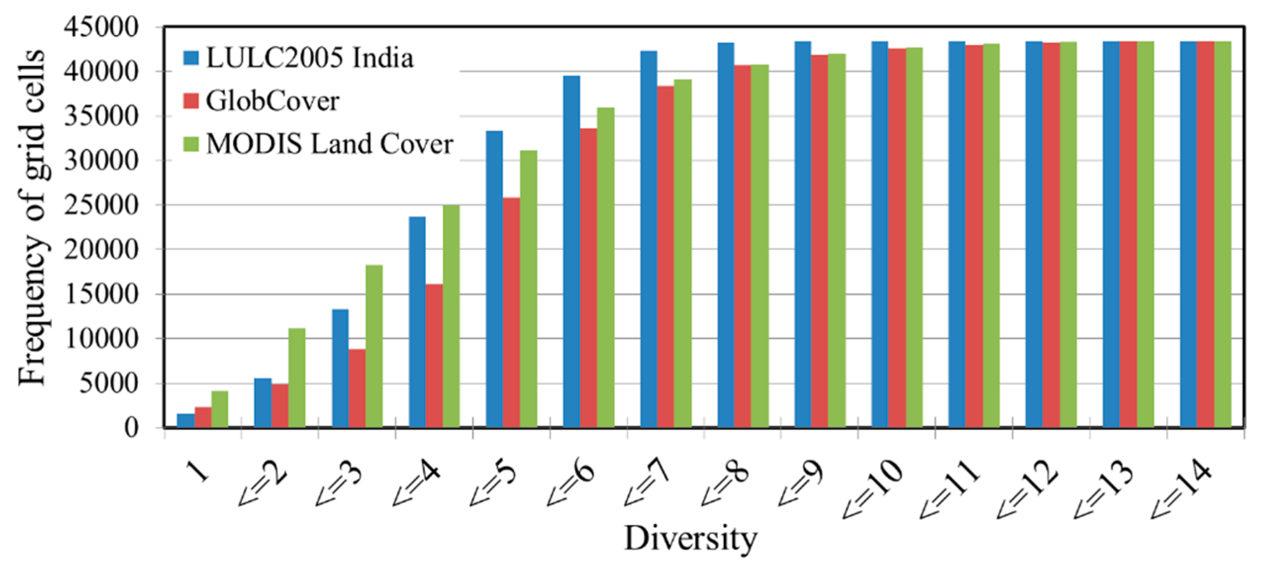
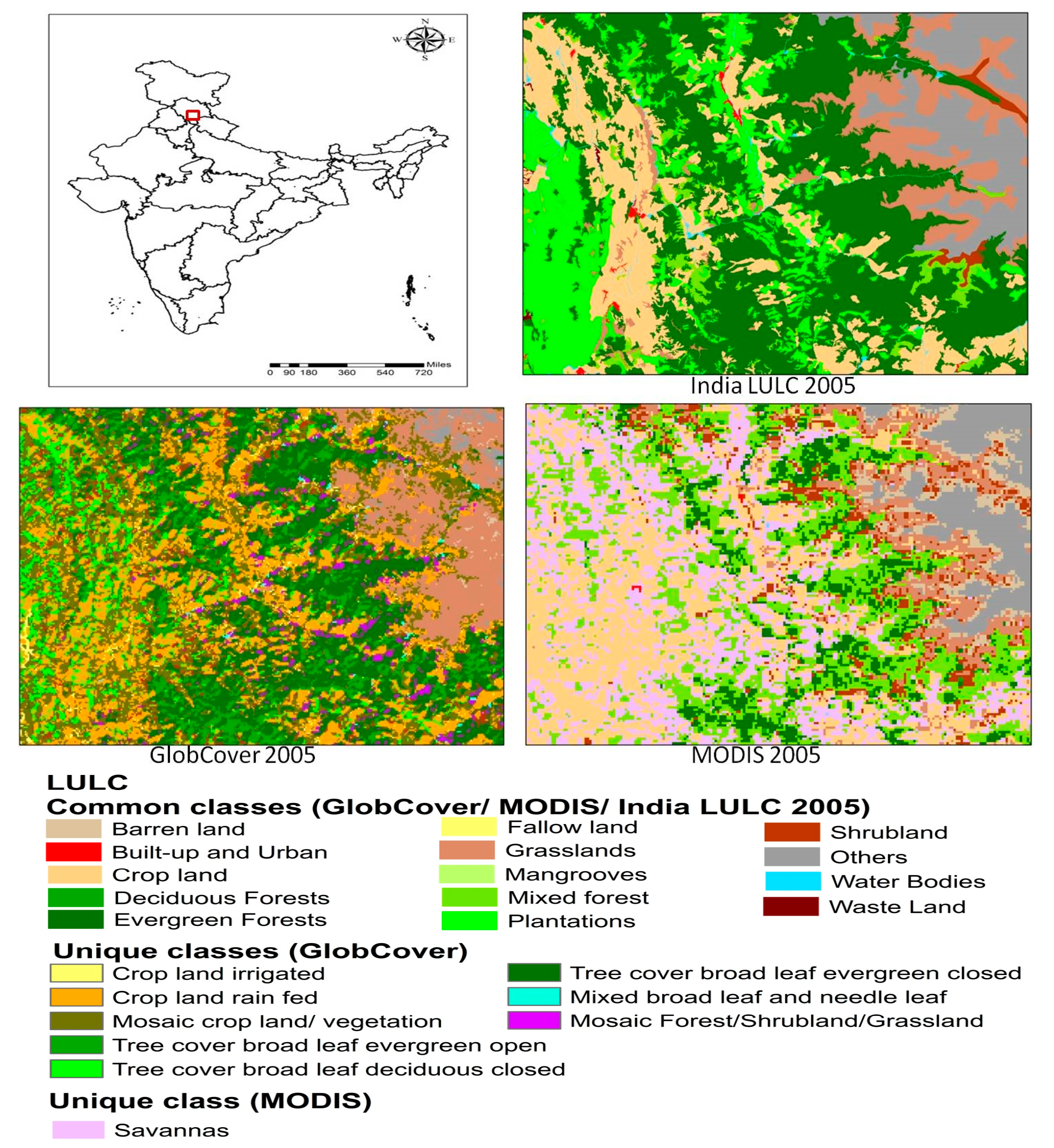
2.3. Comparison of LULC Maps with Other Global and Conventional LULC Data
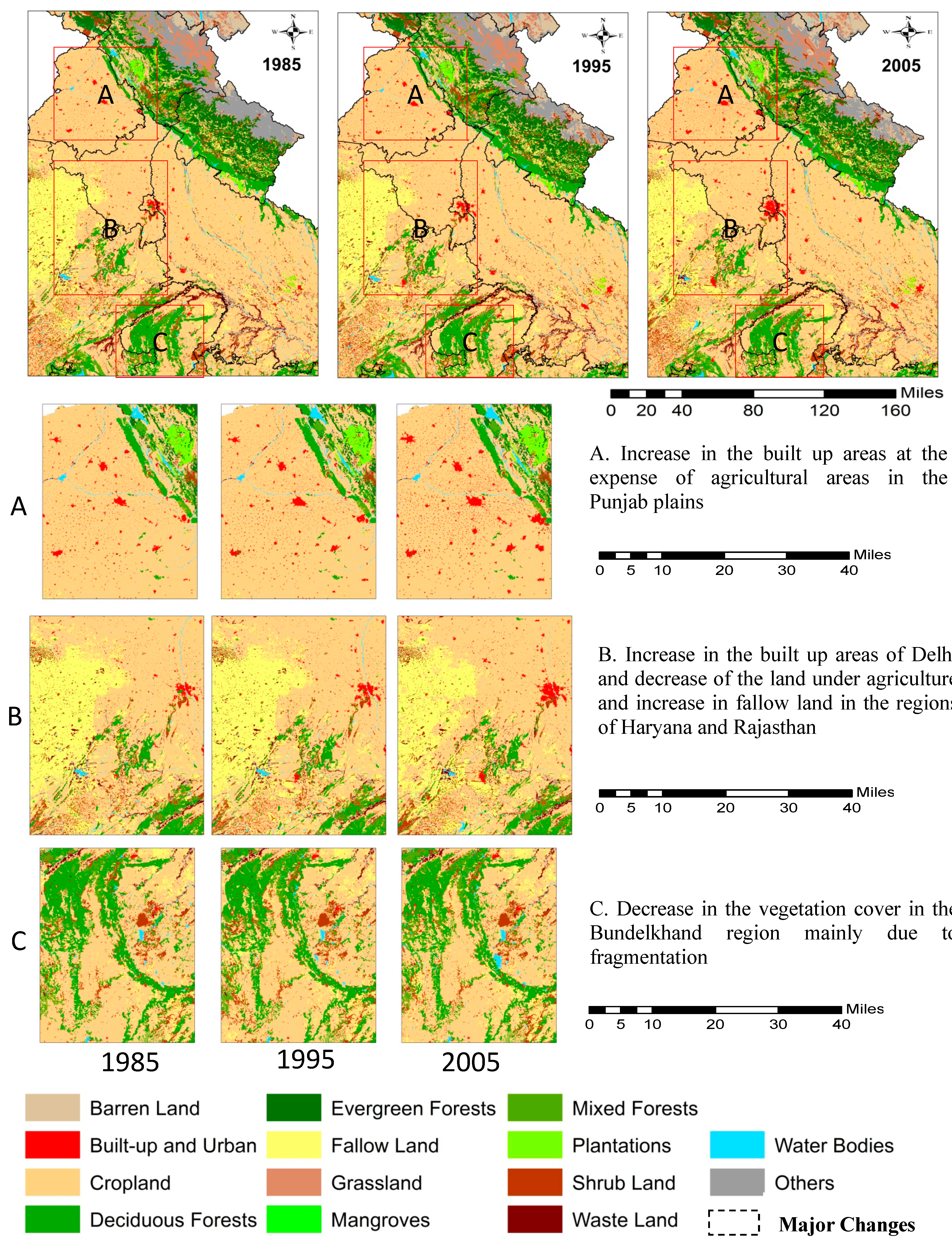
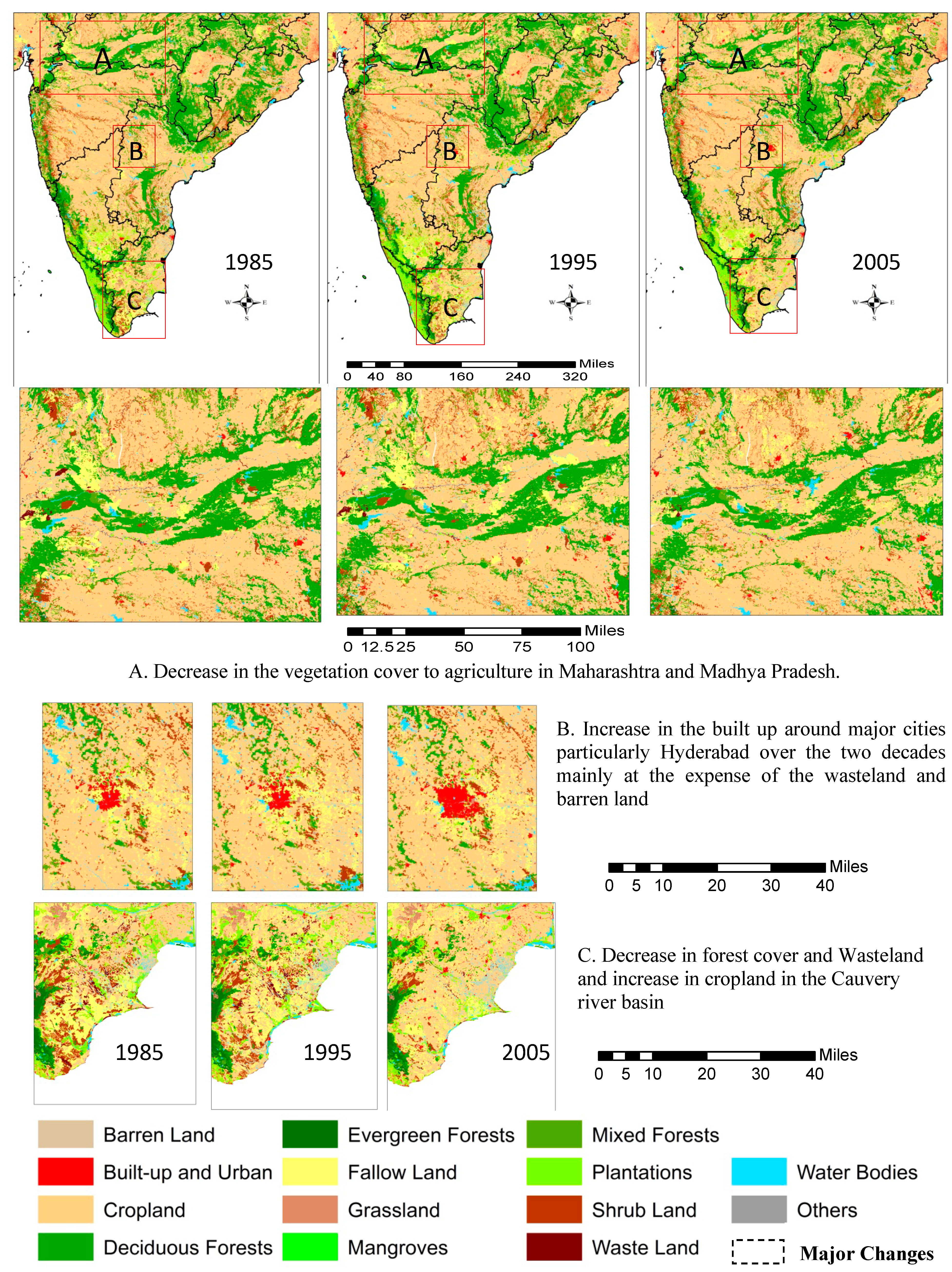
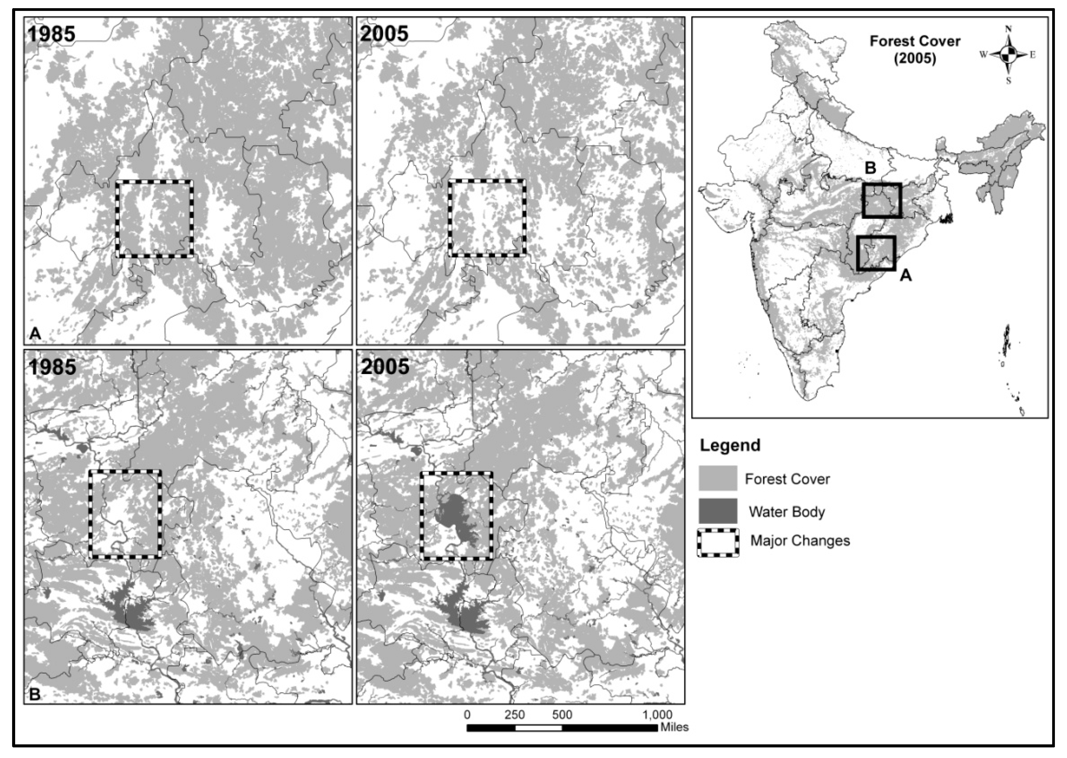
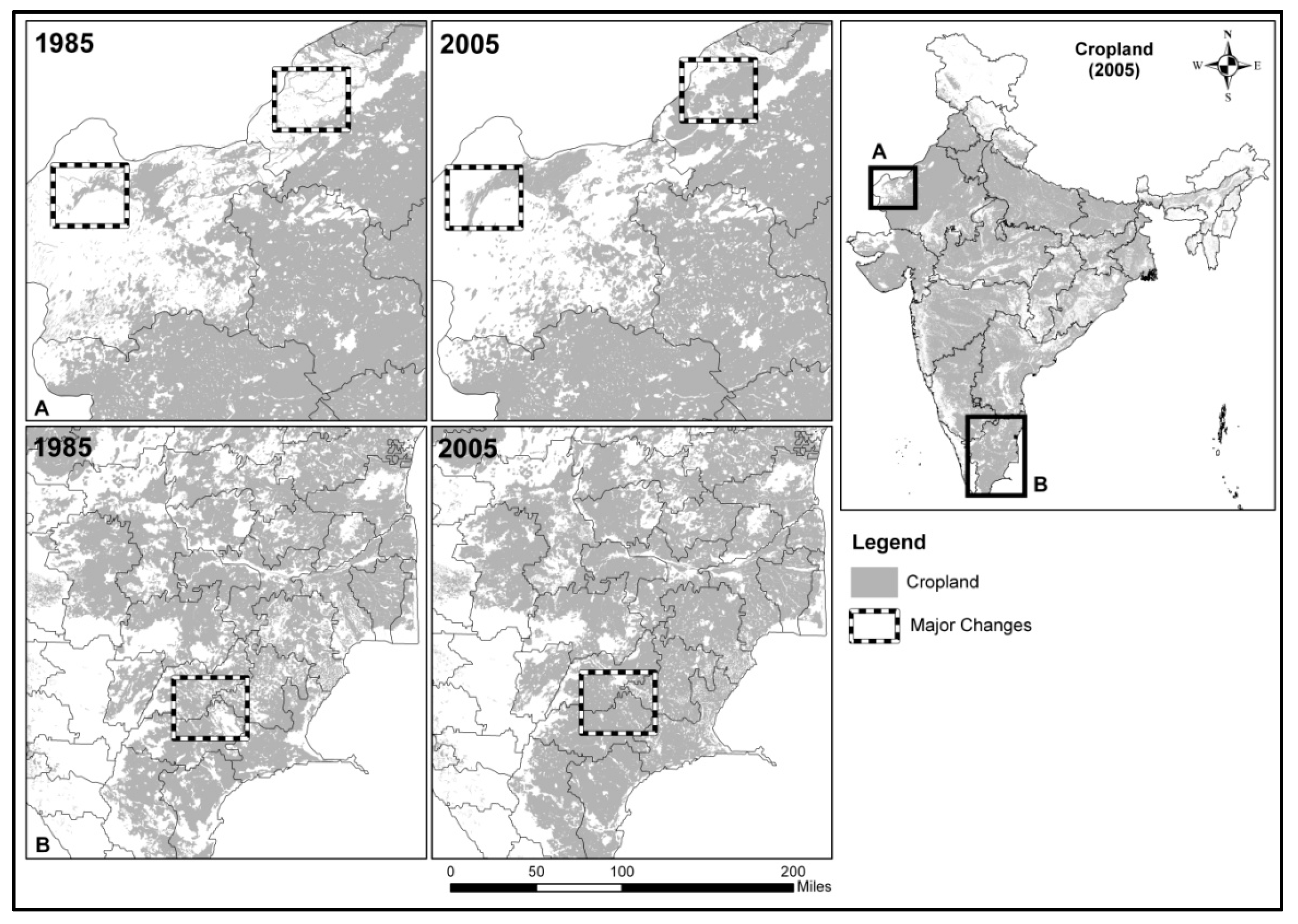
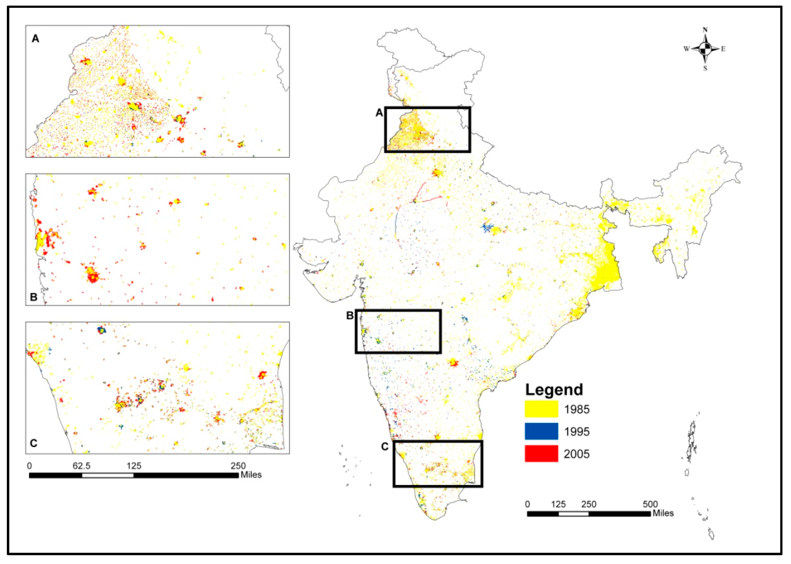
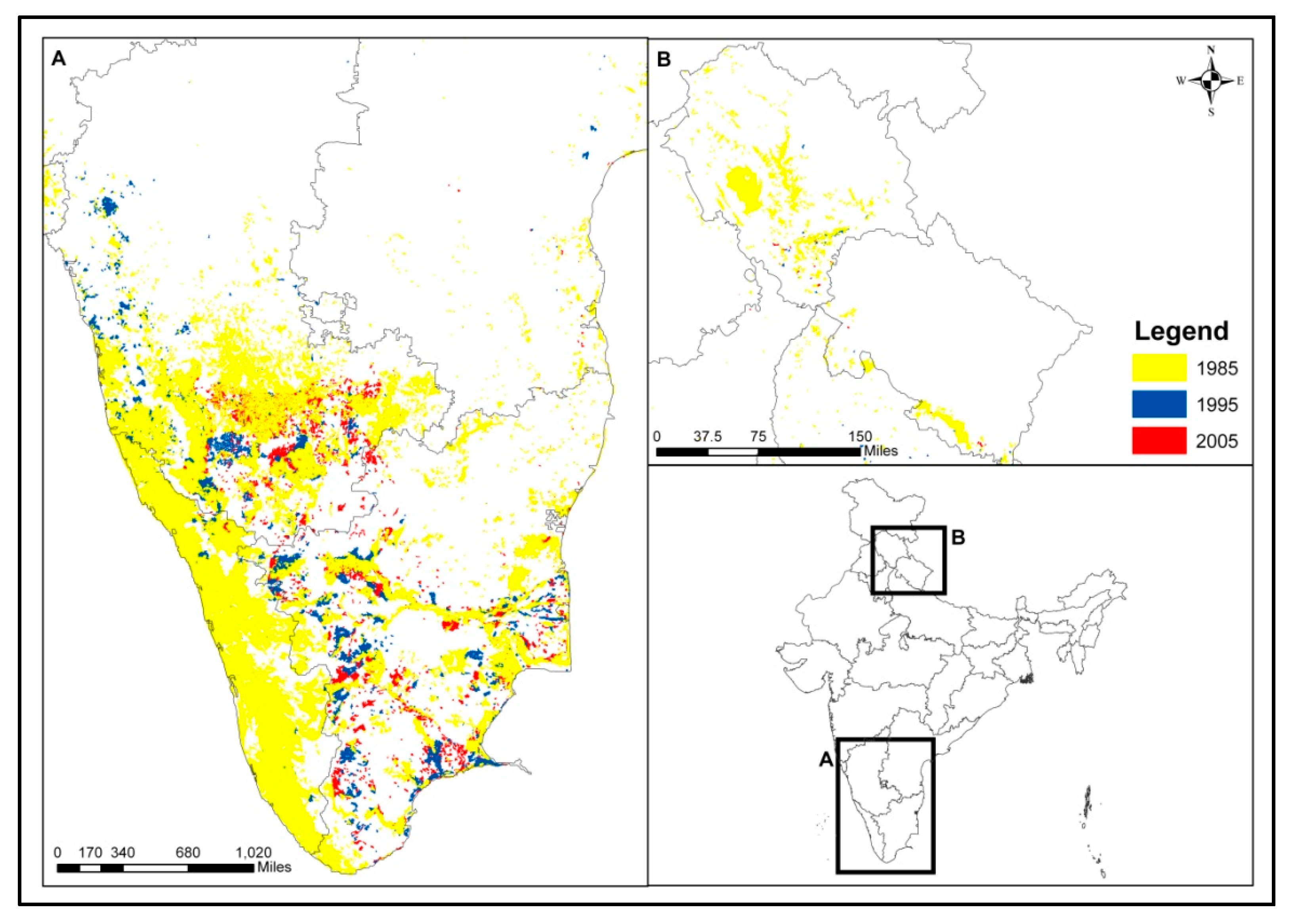
We compared our LULC 2005 map with other available global land cover products viz., MODIS land product and GlobCover maps. It is to be noted that these three products vary in spatial resolution. The LULC 2005 map has 30 m spatial resolution, whereas MODIS land products and GlobCover have 500 m and 300 m resolutions respectively. In addition, the MODIS and LULC 2005 India maps are based on IGBP classification scheme, whereas the GlobCover map uses large number of vegetation mosaic classes, irrigated and non-irrigated crops (Table S1). The overall accuracy of GlobCover is 67.10% with Kappa value of 0.656 [38]. The cumulative patch diversity within 10 × 10 km grid indicates that MODIS land product captures the lowest diversity. The GlobCover has higher frequency of lower patch diversity numbers (0–3), while LULC 2005 India map captures highest cumulative patch diversity frequency for more than 3 patch numbers. Therefore, it is evident that the LULC 2005 map of India developed in this present study is able to capture the maximum landscape diversity of LULC classes (Figure 10). As a result of the variations in spatial resolution of the three products, their effect on the mapping details, class definition and generalization are evident (Figure 11) [57].
Figure 10. Comparative evaluation of LULC 2005 India product with MODIS Land Product and GlobCover using cumulative diversity of patch classes.
Remotesensing 07 02401 g010
Figure 11. Comparison of resolution of LULC 2005 India product with MODIS Land Product and GlobCover—2005.
Remotesensing 07 02401 g011

2.4. Trend of LULCC

There has been a progressive expansion in agricultural cropland and intensification with management inputs [8,9]. The irrigation projects have contributed to the intensification of agriculture to meet the local and global market demands with more focus on cash crop cultivation [58,59]. The present study reports considerable decrease in cropland area in 1985 due to deficit in rainfall during 1984–1986 compared to 1995 and 2005. During 1995 and 2005, there has been an increase in the crop area due to high number of good monsoon years showing high correlation between cropping area and annual precipitation; thereby, confirming the monsoon-dependent agriculture system in the country (Figure 12).
In contrast to the State Forest Reports (SFR) brought out by the Forest Survey of India (FSI) [23], we have observed a consistent decrease in forest cover over the last two decades. The increase in forest area over the years reported by the FSI is attributed to the inclusion of trees outside the forest area in its forest cover mapping. Furthermore, the total area under forest in this study is more than that reported forest area by FSI (SFR, 1987, 1997 and 2009) as woodlands which account for ~1.5% of the total geographical area (TGA) which has been included in our forest category. Besides FSI methodology for mapping vegetation and tree outside forest has also been questioned [60].
Figure 12. The monthly average rainfall pattern was lowest during 1984–1986 (A); compared to 1994–1996 (B); and 2004–2006 (C). The rainfall pattern has affected net cropland area during the mapping periods.
Remotesensing 07 02401 g012aRemotesensing 07 02401 g012b
The Indira Gandhi Canal system, Narmada project and other national programs under Accelerated Irrigation Benefit Programme (AIBP) seem to be responsible for the observed increase in cropland area and decrease in fallow land area around these project regions. The progressive deforestation due to mining (coal, iron and aluminum ores) [61,62,63], illegal felling and encroachment in the central India [64], decrease in forest area during 1985–2005 due to major dams and reservoirs (13,744 ha in Sardar Sarovar Project, Narmada and 4193 ha in Tehri) [64,65,66], logging and shifting cultivation in North Eastern India [67], mining, conversion of forest land to various land uses are other possible drivers of LULCC [61,62]. One of the positive impacts of government policies has been noticed such as a decline in wasteland in 2005 due to focused watershed schemes for soil and water conservation and linking of Mahatma Gandhi National Rural Employment Guarantee Act (MGNREGA) for afforestation [68]. The change patterns observed in the data can be attributed to the socio-economic development in the region. The observations in the central Indian region of Deccan plateau and Chotanagpur plateau indicate progressive increase in deforestation for agriculture.

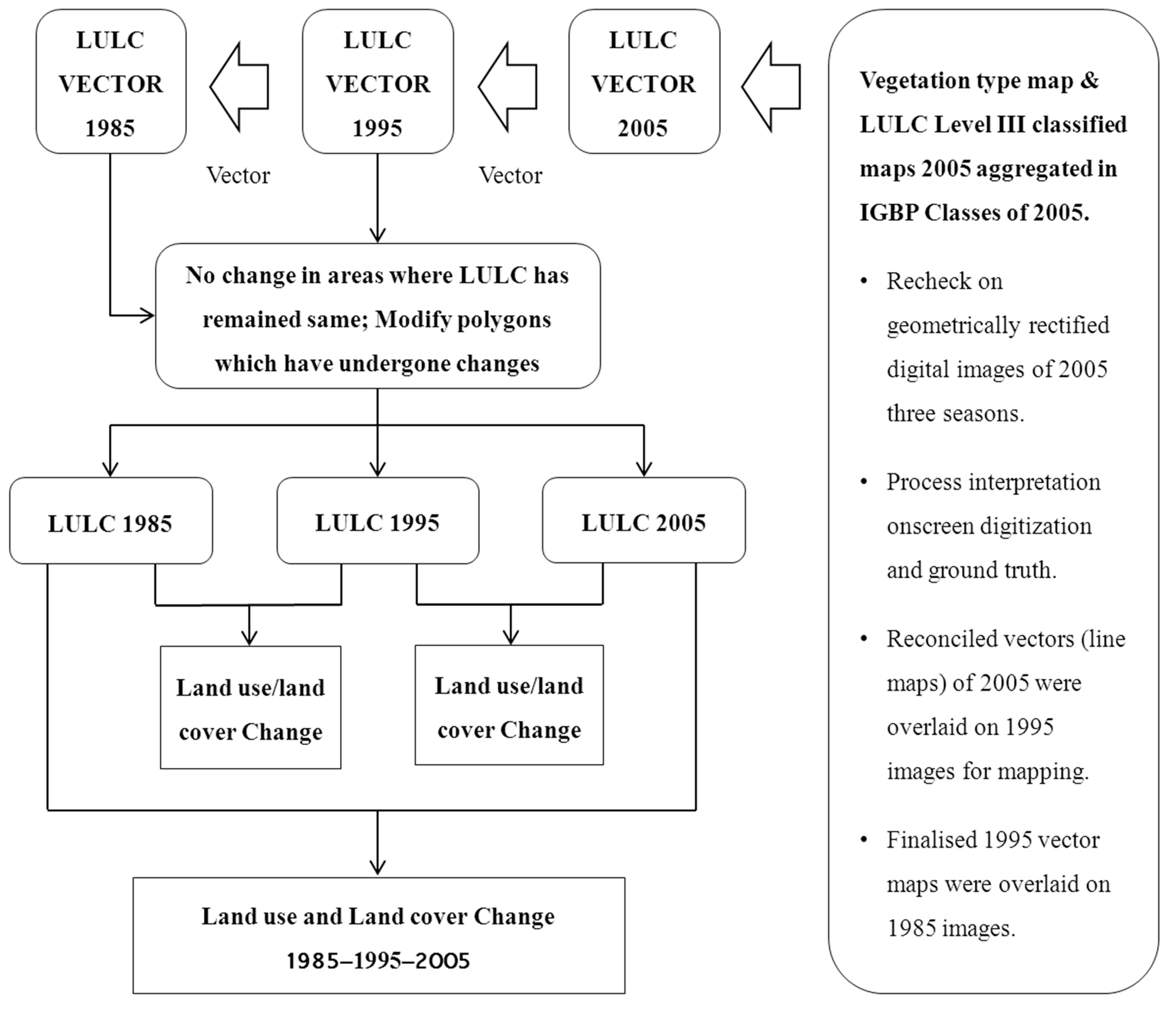
3. Experimental Section

3.1. Material and Methods

3.1.1 Satellite Data
The study uses multi-temporal data from different satellite systems for LULC mapping. The geometrically co-registered (with sub-pixel accuracy) open source Landsat MSS/TM [69], IRS 1C–LISS III, and Resourcesat1 [70] data for three seasons, viz. winter (January to March); pre-monsoon (April to May) and post-monsoon (mid-October to December) form the main data for our analysis [70]. The Landsat MSS/TM images were downloaded from the United States Geological Survey (USGS) portal. When cloud free Landsat data was unavailable, IRS 1C–LISS III (1994–1995) and Resourcesat 1 (2004–2005) images were used by geometrically correcting them with sub-pixel accuracy, with respect to Landsat data (ortho-rectified) (Table S2; see supplementary material for details on the rectification procedure). We used first order polynomial equation with allowable Root Mean Square (RMS) error of less than one pixel (default) for geometric rectification. The RMS error was found to be 0.4 pixels (less than 9.2 m) in case of LISS-III data, with minimum of 15 Ground Control Points GCPs in each scene having a range of 0.35 to 0.60 pixels (i.e., 8 to 15 m). Highest error was found in the mountainous regions; however, in case of LISS-1 and MSS data, the mean RMS was 0.8 pixels (54 m in case of LISS-1 and ~52 m in case of MSS data). A minimum of 15 GCPs was taken for flat terrains and 30 GCPS for hilly terrain to geo-rectify the satellite images. Parts of eastern Himalaya, for instance, Arunachal Pradesh have perpetual cloud covers; hence, cloud free data of the nearest years have been used for mapping. The details of data from different satellite sensors used in the present study are given in Table 4 and the details of the path and row of the acquired data is presented in the supporting information (Table S2).
Table 4. Satellite remote sensing data used for the LULC mapping.
S. No.PeriodSatellite SystemSensor SystemSpatial Resolution of Products Supplied (m)
11984–1985Landsat MSS 80 (resample to 60 * m)
21994–1995Landsat and IRS 1BTM, LISS I 30 and 72 m (resample to 56 m *) respectively
32004–2005Landsat and Resourcesat ITM, LISS III30 and 23.5 * m respectively
Note: * Finally, all the digital data were re-sampled to 30 m for on screen visual interpretation at 1:50000 scale using nearest neighbor technique.

3.2. Classification Scheme

The hierarchical classification scheme adopted in this study is based on the guidelines formulated by the Anderson classification scheme [31]. The suggested classification offers more consistency owing to its ability to accommodate different levels of information starting from structured broad-level classes to systematic sub-division with more detailed sub-classes. At each level, the defined classes are mutually exclusive (Table 3). The classes, namely, built up/urban, wasteland, and cropland are depicting “land use” that describes the landscapes converted by/for human activities. The remaining six groups, namely, forests, water bodies, wetland, grass land, shrub land, and barren land are “land cover” types, and primarily describing features of the natural environment, although, evidence of human disturbance may be present. Level I category is further classified into Level II classes. Level II categories provide greater details of LULC and structural and functional importance of the respective classes. Level I land use information, for example, is efficiently and economically gathered over large areas by satellite data. Similarly, Level II categories are further refined using satellite images for detailed mapping. The level of classification can be presented at a wider range of scales. The Natural Resource Census Level III classification scheme (Table S3) has been aggregated to Level II and used for mapping.
The IGBP hierarchical classification system for LULC mapping and monitoring requirements using medium-resolution satellite remote sensing data [16,45] was adopted. IGBP classification supports transformation to other classification schemes used globally based on the mapping scale and resolution of the data [16]. This ensures mapping the classes with other classifications schemes while assimilating data for climate and LULCC models (Table 3).

3.3. Temporal LULC Mapping

Figure 1 shows the methodology adopted for the decadal (1985-1995-2005) LULC mapping in India. Vegetation type and land use maps of 2005 generated as a part of the ‘Biodiversity Characterization at Landscape Level’ (BCLL) project [26,27] and LULC map [29] were used as available resources. The database was aggregated into 18 classes from the available 150 classes (using hierarchical class merging approach) and converted to a vector map using webGIS tool. The 2005 LULC vector map was overlaid on the satellite data (Landsat TM 2005) for three seasons to check for interpretation and aggregated details in vector form. Extensive ground truth data was collected using existing field transects with high-resolution satellite images. The errors and discrepancies in the 2005 LULC map were corrected using the ground truth data and ancillary information supplemented by existing maps to produce the final map. Since 2005, the LULC map was used as a reference for mapping of 1995 and 1985 LULC, utmost care was taken while preparing the 2005 map. The on-screen image interpretation technique was used to prepare the LULC maps with the minimum mapping unit of 2.5 hectares. A standardized methodology was prepared to assist different working groups involved in the mapping exercise. Each working group was given training on how to use the methodology and to bring uniformity. The 2005 LULC map was overlaid on the 1995 satellite data (Landsat TM) and the regions/polygons where the changes had been taken place were realized with respect to 2005 LULC map. The interpretation inconsistencies were also corrected based on the ground information to prepare 1995 LULC map. The final map of 1995 was further overlaid on 1985 satellite data (Landsat MSS/resample resolution 56 m as provided by USGS: http://glovis.usgs.gov) and the same procedure was repeated to produce the 1985 LULC map (Figure S1). The maps were then crossed to generate the change areas. Field surveys were also carried out in 5% of the noted change areas to ascertain the nature of change, their extent and direction of change. The nature and extent of the LULC changes were verified from the ground truth data and records from various revenue and forest departments of the respective states (Figures S2 and S3). Thus, the 2005, 1995, and 1985 LULC maps provide reliable and accurate information on the magnitude of LULCC (Figure 2, Figure 3, Figure 4 and Figure 5 and Figure 8, Figure 9, Figure 10 and Figure 11). The LULC India maps of 1995 and 1985 are included as supplementary (Figures S4 and S5).

3.4. Comparison of LULC 2005 Map with Other Global Land Products

The information content of LULC 2005 India map was compared with other two coarser resolution LULC products viz., MODIS [34,71,72] and GlobCover [73,74]. MODIS land cover products have been generated using supervised digital classification using training database of the sites that are distributed globally [71]. The overall accuracy of the MODIS maps is reported to be 75% but higher accuracies range in the class specific categories, at large [35]. More recently, the European Space Agency (ESA) has produced 300 m spatial resolution global land cover product GlobCover [73,74]. The classification process includes unsupervised clustering of selected mosaics using the time series MERIS image mosaics [73].
We have used cumulative diversity index as our metric to compare the three maps. Cumulative diversity is a measure of the number of variety of land cover classes present in a unit landscape. The more classes there are, the more diverse or rich the area is. Therefore, comparing cumulative diversity across three maps indicates which satellite data is better in capturing the compositional makeup of the landscape. To calculate cumulative diversity was overlaid a 10 × 10 km grid mask on the maps, and calculated the number of unique land cover classes (diversity) within each mask grid cell. We then compared the cumulative frequency distribution of the number of grid cells vs. landscape diversity across the three maps (Figure 11). While the index is easily calculated and interpreted, it does not render any detail on the size of each class, and therefore its importance. Even if a certain class covers the smallest possible area, it is counted.
Table 5. Accuracy of evaluation of LULC types for the year 2005.
Land Classification *BuClFlFoPlSlGlBlWlWbTotalUA
Bu713 21 8 74296.09
Cl 1478 2711 4150298.40
Fl12 1116 2445116196.12
Fo 9 16892314 173597.35
Pl 114721527 60686.96
Sl23 37 128918 32 139992.14
Gl 2436 728148227 158693.44
Bl49 2365636 76485.86
Wl 57312681813 1389 154290.08
Wb 15691569100.00
Total797157912511773567135615476821476157812,6060.936
PA89.4693.6089.2195.2692.9595.0695.8096.1994.1199.430.941
Overall accuracy = 94.46%; Kappa Accuracy = 0.9445
* Bu: Built-up/Urban; Cl: Cropland; Fl: Fallow-land; Fo: Forest; Pl: Plantations; Sl: Shrub-land; Gl: Grassland; Bl: Barren-land; Wl: Waste-land; Wb: Water bodies; UA: Users accuracy per cent; PA: Producer accuracy in per cent.

3.5. Accuracy Assessment

During the national BCCL project, ~20,000 sample points were collected to determine species richness, endemism and ecological significance of species, to validate vegetation type and land use maps. Out of ~20,000 sample points, 12,606 were from the years, 2004–2005, distributed uniformly in different LULC classes. In inaccessible areas, the Google satellite images of very high resolution were used to determine Level I LULC class. Post-mapping, ground-verified site-specific accuracy assessment technique was used to evaluate the Level I classes of LULC 2005 map [75,76] using above sample points. The sample points were overlaid on 30 m raster map of 2005 to evaluate the consumer, producer, Kappa and overall accuracies [75] of the Level I classes of LULC 2005 map (Table 5). In the absence of field sample points during 1985 and 1995, no accuracy estimation has been conducted. The LULC 2005 map prepared in this study is a product of detailed visually interpreted vegetation types and LULC maps (Level III) on 1:50K scale (Figure 1). The class-aggregated vectors were overlaid on satellite images and boundaries were refined using new ground truth data and Google Earth images. The interpreted vectors of 2005 were overlaid on 1995 to prepare 1995 maps. The polygons that have undergone changes have been modified using same interpretation key. The same process was repeated to prepare 1985 map from the 1995 map. Hence, the continuity of accuracy levels was ensured.

4. Conclusions

In this article, we have reported a methodology followed by detailed results from national-level LULCC mapping activity for India using multi-temporal and multi-spectral medium resolution satellite data. Our analysis shows that the LULC in India has undergone important changes between 1985 and 2005. The total area that has changed during 1985–2005 is 0.10% of the total geographic area of the country (~340,932 km2). During this period, there has been a continuous decrease in land cover in the form of forests with concomitant increase in cropland and built-up area. Between 1985 and 2005, of the 11 major LULC classes, considerable increase has been recorded in agriculture (47.55%–49.34%) and built-up areas (1.03%–1.44%), whereas significant decrease was noticed for forests (23.25%–22.18%), and wastelands (2.57%–2.27%). Within different forest classes, areas under mixed forest, savannah/woodlands/scattered trees, and mangroves, have shown marginal increase. All the other forest classes remained either unchanged or declined marginally. Other LULC classes including barren land (2.00%–2.13%), plantations (2.36%–2.38%), and shrub land (5.56%–5.65%) also recorded marginal changes in their areas. Grassland remained unchanged, whereas marginal increase in shrub land area was noticed (Table 2). In the long run, this database can be used for the biogeochemical and hydrological modeling at pan-India scales, and also as an input to regional and global climate models. The follow-on of the present work will investigate: (1) The drivers of observed LULCC between 1985 and 2005; (2) Reconstruct the historical LULCC for India between 1950 and 2011 by combining satellite information with census statistics; (3) Generate scenarios of future LULCC to support national level environmental assessments; and (4) Update the LULC satellite database for 2015 as a continuing effort of this study. The dataset can be used in ecosystem modeling studies including land cover dynamics and global climate change. These maps provide in-depth understanding of LULCC (e.g., degradation, desertification and biodiversity loss and physical and human forces behind these processes). Additionally, they will improve our understanding of the linkages between LULCC and climate change, food production, health, urbanization, coastal zone management, trans-boundary migration, and in identifying sites for renewable energy and availability and quality of water. Furthermore, these maps will enable identification of vulnerable areas of land degradation process, changing patterns of precipitation and temperature, and shifts in the biome boundary distribution.

Supplementary Files

Supplementary File 1

Acknowledgments

The research publication uses vegetation type and LULC map at 1:50000 scale prepared by the Indian Space Research Organization (ISRO) (available from http://bis.iirs.gov.in and http://bhuvan.nrsc.gov.in). We thank ISRO and all the team members who have participated in the preparation of the referred maps. We also acknowledge USGS for making us available Landsat data set for the periods of 1985, 1995 and 2005 for undertaking mapping at national level. The manuscript preparation was carried out under a visiting fellowship to the University of Illinois offered to Parth S. Roy under NASA grants No: NNX414AD94G. Parth S. Roy is Chair Professor with funding support from Department of Science & Technology (NRDMS), Government of India. The support is acknowledged. Authors sincerely acknowledge the learned anonymous reviewers for providing valuable comments/suggestions to improve the quality of this research article.

Author Contributions

Parth S. RoyPrincipal investigator, conceptualizing the research, preparation of manual and writing the article.
Arijit RoyMapping, support in methodology manual preparation, and input in manuscript preparation.
Pawan K. JoshiMapping, support in methodology manual preparation, and input in manuscript preparation.
Manish P. KaleMapping, support in methodology manual preparation, and input in manuscript preparation.
Vijay K. SrivastavaPreparation of methodology manual, mapping and overall coordination.
Sushil K. SrivastavCoordination of refinement, edge matching, coordination of cleaning data base and editorial inputs in the manuscript.
Ravi S. DwivediTechnical guidance for methodology manual, supervising mapping, reviewing the manuscript at various stages and support coordination.
Chitiz JoshiEdge matching, creation and cleaning of data bases.
Mukund D. BeheraSupport in conceptualizing research and preparation of manuscript.
Prasanth MeiyappanSupport in conceptualizing research, comparison of 2005 map with other global data sets, and preparation of manuscript.
Yeshu SharmaPreparation of national data base, area calculation, and conversion of existing data base to 1 km grid data base.
Atul K. JainConceptualizing and motivating to prepare the research article and support in writing.
Jamuna S. SinghReviewed the revised manuscript, classification scheme and advice.
Yajnaseni PalchowdhuriMapping and creation of data base.
Reshma. M. RamachandranMapping and creation of data base.
Bhavani PinjarlaMapping and creation of data base.
Vishnubhotla Chakravarthi Support in formulating the research, manuscript preparation and reviewing
Nani B. BattuMapping and creation of data base.
Mahalakshmi S. GowsalyaMapping and creation of data base.
Praveen ThiruvengadamMapping and creation of data base.
Mrinalni KotteeswaranMapping and creation of data base.
Vishnu Priya Mapping and creation of data base.
Krishna Murthy V.N. YelishettyGuiding teams involved in mapping and data bases.
Sandeep MaithaniInternal quality checking of LULC data sets
Gautam TalukdarMapping and creation of data base.
Indranil MondalMapping and creation of data base.
Krishnan S. RajanLeading and guiding a team involved in mapping and data base.
Prasad S. NarendraLeading and guiding a team involved in mapping and data base.
Sushmita BiswalMapping and creation of data base.
Anusheema ChakrabortyMapping and creation of data base.
Hitendra PadaliaMapping and creation of data base.
Manoj ChavanMapping and creation of data base.
Satish N. PardeshiMapping and creation of data base.
Swapnil A. ChaudhariMapping and creation of data base.
Arur AnandMapping and creation of data base.
Anjana VyasLeading and guiding a team involved in mapping and data base.
Mruthyunjaya K. ReddyLeading and guiding a team involved in mapping and data base.
M. RamalingamLeading and guiding a team involved in mapping and data base.
R. ManonmaniMapping and creation of data base.
Pritirangan BeheraMapping and creation of data base.
Pulok DasMapping and creation of data base.
Poonam TripathyMapping and creation of data base.
Shafique MatinMapping and creation of data base.
Mohammed L. KhanLeading and guiding a team involved in mapping and data base.
Om P. TripathiMapping and creation of data base.
Jyotihman DekaMapping and creation of data base.
Prasanna Kumar Mapping and creation of data base.
Deepak KushwahaMapping and creation of data base.

Conflicts of Interest

The authors declare no conflict of interest.

References

  1. NRC. Advancing Land Change Modeling: Opportunities and Research Requirements; National Academy Press: Washington, DC, USA, 2014; p. 152.
  2. Rogan, J.; Chen, D. Remote sensing technology for mapping and monitoring land-cover and land-use change. Prog. Plann. 2004, 61, 301–325. [Google Scholar] [CrossRef]
  3. Pielke, R.A.; Pitman, A.; Niyogi, D.; Mahmood, R.; McAlpine, C.; Hossain, F.; Goldewijk, K.K.; Nair, U.; Betts, R.; Fall, S.; et al. Land use/land cover changes and climate: Modelling analysis and observational evidence. WIREs Climate Change 2011, 2, 828–850. [Google Scholar]
  4. Houghton, R.A.; House, J.I.; Pongratz, J.; van der Werf, G.R.; de Fries, R.S.; Hansen, M.C.; Le Quéré, C.; Ramankutty, N. Carbon emissions from land use and land-cover change. Biogeosciences 2012, 9, 5125–5142. [Google Scholar] [CrossRef]
  5. Phalan, B.; Onial, M.; Balmford, A.; Green, R.E. Reconciling food production and biodiversity conservation: Land sharing and land sparing compared. Science 2011, 333, 1289–1291. [Google Scholar] [CrossRef] [PubMed]
  6. Bennett, E.M.; Carpenter, S.R.; Caraco, N.F. Human impact on erodable phosphorus and eutrophication: A global perspective. BioScience 2001, 51, 227–234. [Google Scholar] [CrossRef]
  7. Agarwal, C.; Green, G.M.; Grove, J.M.; Evans, T.P.; Schweik, C.M. A Review and Assessment of Land-Use Change Models: Dynamics of Space, Time and Human Choice; U.S. Department of Agriculture, Forest Service, Northeastern Research Station: Newton Square, PA, USA, 2002; p. 61. [Google Scholar]
  8. Flint, E. Historical reconstruction of changes in land use and land cover of vegetation in the Gangetic Plain, 1950–1980: Methodology and case studies. In Land Use Historical Perspective—Focus on Indo-Gangetic plains; ISBN 81-7764-274-X; Allied Publishers Pvt. Limited: New Delhi, India, 2002. [Google Scholar]
  9. Abrol, Y.P.; Sangwan, S.; Tiwari, M.K. Land Use Historical Perspective—Focus on Indo-Gangetic Plains; ISBN 81-7764-274-X; Allied Publishers Pvt. Limited: New Delhi, India, 2002; p. 182. [Google Scholar]
  10. Zhao, Y.; Zhang, K.; Fu, Y.; Zhang, H. Examining land-use/land-cover change in the Lake Dianchi watershed of the Yunnan-Guizhou Plateau of Southwest China with remote sensing and GIS techniques: 1974–2008. Int. J. Environ. Res. Public Health 2012, 9, 3843–3865. [Google Scholar] [CrossRef] [PubMed]
  11. Soularda, C.E.; Wilsona, T.S. Recent land-use/land-cover change in the Central California Valley. J. Land Use Sci. 2015, 10, 59–80. [Google Scholar] [CrossRef]
  12. Fonji, S.F.; Taff, G.N. Using satellite data to monitor land-use land-cover change in North-eastern Latvia. SpringerPlus 2014, 3. [Google Scholar] [CrossRef] [PubMed]
  13. Lambin, E.F.; Geist, H. Land Use and Land Cover Change—Local Process and Global Impact; Springer Berlin Heidelberg: Berlin, Germany, 2006; p. 222. [Google Scholar]
  14. Relating Land Use and Global Land-Cover Change: A Proposal for an IGBP-HDP Core Project; IGBP Report; Turner, B.L.; Moss, R.H.; Skole, D.L. (Eds.) IGBP Secretariat: Stockholm, Sweden, 1993; p. 82.
  15. Turner, B.L.; Skole, D.L. Land-Use and Land-Cover: Science/Research Plan; IGBP Report No. 35; IGBP: Stockholm, Sweden, 1995. [Google Scholar]
  16. IGBP/IHDP. Land-Use and Land-Cover Change: Implementation Strategy; IGBP Report No. 48, IHDP Report No. 10; IHDP: Bonn, Germany, 1999. [Google Scholar]
  17. Lambin, E.F.; Turner, B.L., II; Geist, H.J.; Agbola, S.B.; Angelsen, A.; Bruce, J.W.; Coomes, O.T.; Dirzo, R.; Fischer, G.; Folke, C.; et al. The causes of land-use and land-cover change—Moving beyond the myths. Glob. Environ. Change 2001, 11, 5–13. [Google Scholar]
  18. Manakos, I.; Braun, B. (Eds.) Land Use and Land Cover Mapping in Europe: Practices & Trends; Springer Science: Dordrecht, The Netherlands, 2014; p. 441.
  19. Roy, P.S.; Murthy, M.S. Efficient land use planning and policies using geospatial inputs—An Indian experience. In Land Use Policy; Denman, A.C., Penrod, O.M., Eds.; Nova Science Publishers, Inc.: New York, NY, USA, 2009; p. 43. [Google Scholar]
  20. Rao, D.P.; Gautam, N.C.; Karale, R.L.; Sahai, B. IRS-1A application for land use/land cover mapping in India. Current Sci. 1991, 61, 153–161. [Google Scholar]
  21. Rao, D.P.; Gautam, N.C.; Nagaraja, R.; Ram Mohan, P. IRS-1C applications in land use mapping and planning. Current Sci. 1996, 70, 575–581. [Google Scholar]
  22. National Remote Sensing Agency. Forest Cover Assessment of India Using Satellite Remote Sensing Data during 1972–1975 and 1980–1982 Periods, Tech. Rep. 1985.
  23. India State of Forest Report; Forest Survey of India, Ministry of Environment and Forest, Govt. of India: Dehradun, India, 2013; p. 252.
  24. Joshi, P.K.; Roy, P.S.; Singh, S.; Agarwal, S.; Yadav, D. Vegetation cover mapping in India using multi-temporal IRS Wide Field Sensor (WiFS) data. Remote Sens. Environ. 2006, 103, 190–202. [Google Scholar] [CrossRef]
  25. Roy, P.S.; Joshi, P.K.; Singh, S.; Agarwal, S.; Yadav, D.; Jegannathan, C. Biome mapping in India using vegetation type map derived using temporal satellite data and environmental parameters. Ecol. Model. 2006, 197, 148–158. [Google Scholar] [CrossRef]
  26. Biodiversity Information System. Referred for Vegetation Type Map of India Prepared from Satellite Remote Sensing 2005 Data Set at 1:50000 Scale. Available online: http://bis.iirs.gov.in/ (accessed on 23 August 2014).
  27. Roy, P.S.; Kushwaha, S.P.S.; Murthy, M.S.R.; Roy, A.; Kushwaha, D.; Reddy, C.S.; Behera, M.D.; Mathur, V.B.; Padalia, H.; Saran, S.; et al. Biodiversity Characterization at Landscape Level: National Assessment 2012; Indian Institute of Remote Sensing: Dehradun, India, 2012; p. 140. [Google Scholar]
  28. Kandrika, S.; Roy, P.S. Land use land cover classification of Orissa using multi-temporal IRS-P6 AWiFS data: A decision tree approach. Int. J. Appl. Earth Obs. Geoinf. 2008, 10, 186–193. [Google Scholar] [CrossRef]
  29. LULC Cover Map of India 2005 at 1:50000 Scale. Available online: http://bhuvan.nrsc.gov.in (accessed on 23 August 2014).
  30. Brown, J.F.; Loveland, T.R.; Merchant, J.W.; Reed, B.C.; Ohlen, D.O. Using multisource data in global land cover characterization: Concepts, requirements and methods. Photogram. Eng. Remote Sens. 1993, 59, 977–987. [Google Scholar]
  31. Anderson, J.R. Land use classification schemes used in selected recent geographic applications of remote sensing. Photogram. Eng. Remote Sens. 1971, 37, 379–387. [Google Scholar]
  32. De Fries, R.; Hansen, M.; Townshend, J. Global discrimination of land cover types from metrics derived from AVHRR Pathfinder data. Remote Sens. Environ. 1995, 54, 209–222. [Google Scholar] [CrossRef]
  33. Bartholome, E.; Belward, A.S. GLC2000: A new approach to global land covers mapping from Earth observation data. Int. J. Remote Sens. 2005, 26, 1959–1977. [Google Scholar] [CrossRef]
  34. Chilar, J. Land cover mapping of large areas from satellites: Status and research priorities. Int. J. Remote Sens. 2000, 21, 1093–1114. [Google Scholar] [CrossRef]
  35. Friedl, M.A.; Sulla-Menashe, D.; Tan, B.; Schneider, A.; Ramankutty, N.; Sibley, A.; Huang, X. MODIS collection 5 global land cover: Algirithm refinements and characterisation of new datasets. Remote Sens. Environ. 2010, 114, 168–182. [Google Scholar] [CrossRef]
  36. Shanwad, U.K.; Patil, V.C.; Honnegowda, H.; Dasog, G.S.; Shashidhar, K.C. Generation of water resources action plan for Medak Nala Watershed in India using remote sensing technology. Aust. J. Basic Appl. Sci. 2011, 5, 2209–2218. [Google Scholar]
  37. Panhalkar, S.; Pawar, C.T. Irrigation Projects and Assessment of Land Use/Land Cover Change of Chikotra Basin (Maharashtra) Using Multitemporal Satllite Data. 2010. Available online: www.geospatialworld.net/paper/application/Articleview.aspx?aid=273 (accessed on 7 September 2010).
  38. Chakraborthy, D.; Dutta, D.; Chandrasekharan, H. Land use indicators of a watershed in arid region, western Rajasthan using remote sensing and GIS. JISRS 2001, 29, 115–128. [Google Scholar]
  39. Sudhakar, S.; Kameshwar Rao, S.V.C. Land use and land cover analysis. In Applications of Remote Sensing; Roy, P.S., Dwivedi, R.S., Vijayan, D., Eds.; NRSC (ISRO): Hyderabad, India, 2010; pp. 21–48. [Google Scholar]
  40. Gupta, P.K.; Punalekar, S.; Singh, R.P.; Panigrahy, S.; Parihar, J.S. Modeling the impact of land use/cover change on the runoff water availability: Case study for the Narmada River Basin. ISRO-NNRMS Bull. 2013, 38, 124–129. [Google Scholar]
  41. India WRIS 2014. Available online: http://www.india-wris.nrsc.gov.in/ (accessed on 2 August 2014).
  42. NDMA 2014. Available online: http://www.ndma.gov.in/en/disaster-data-statistics.html (accessed on 20 July 2014).
  43. Chakraborti, A.K.; Rao, V.V.; Shanker, M.; Suresh Babu, A.V. Performance Evaluation of an Irrigation Project Using Satellite Remote Sensing GIS & GPS. Available online: http://www.gisdevelopment.net/application/agriculture/irrigation/agriir001pf.htm (accessed on 27 August 2014).
  44. Pareta, K.; Pareta, U. Integrated watershed modeling and characterization using GIS and remote sensing techniques. Indian J. Eng. 2012, 1, 25–31. [Google Scholar]
  45. Loveland, T.R.; Belward, A.S. The IGBP-DIS global 1 km land cover data set, DISCover: First results. Int. J. Remote Sens. 1997, 18, 3289–3295. [Google Scholar] [CrossRef]
  46. Joshi, P.K.; Bairwa, B.M.; Sharma, R.; Sinha, V.S.P. Assessing urbanization patterns over India using temporal DMSP-OLS night-time satellite data. Current Sci. 2011, 100, 1479–1482. [Google Scholar]
  47. Pandey, B.; Seto, K.C. Urbanization and agricultural land loss in India: Comparing satellite estimates with census data. J. Environ. Manag. 2014, 148, 53–66. [Google Scholar] [CrossRef]
  48. Rahman, A.; Aggarwal, S.P.; Netzband, M.; Fazal, S. Monitoring urban Sprawl using remote sensing and GIS technique of a fast growing urban centre, India. IEEE Sel. Top. Appl. Earth Obs. Remote Sens. 2011, 4, 56–64. [Google Scholar] [CrossRef]
  49. Houghton, R.A. The emissions of carbon from deforestation and degradation in the tropics: Past trends and future potential. Carbon Manag. 2013, 4, 539–546. [Google Scholar] [CrossRef]
  50. Achard, F.; Eva, H.D.; Stibig, H.J.; Mayaux, P.; Gallego, J.; Richards, T.; Malingreau, J.P. Determination of deforestation rates of the world’s humid tropical forests. Science 2002, 297, 999–1002. [Google Scholar] [CrossRef] [PubMed]
  51. Schneider, N.; Eugster, W. Historical land use changes and mesoscale summer climate on the Swiss Plateau. J. Geophys. Res. 2005, 110. [Google Scholar] [CrossRef]
  52. Running, S.W.; Loveland, T.R.; Pierce, L.L.; Nemani, R.R.; Hunt, E.R. A remote sensing based vegetation classification logic for global land cover analysis. Remote Sens. Environ. 1995, 51, 39–48. [Google Scholar] [CrossRef]
  53. Hanqin, T.; Banger, K.; Bo, T.; Dadhwal, V.K. History of land use in India during 1880–2010: Large-scale land transformations reconstructed from satellite data and historical archives. Glob. Planet. Change 2014, 121, 78–88. [Google Scholar] [CrossRef]
  54. Foley, J.A.; Ramankutty, N.; Kate, A.; Brauman, E.S.; Cassidy, J.S.; Gerber, M.; Johnston, N.D.; Mueller, C.O.; Ray, D.K.; Paul, C.; et al. Solutions for a cultivated planet. Nature 2011, 478, 337–342. [Google Scholar]
  55. Hansen, M.C.; deFries, R.S.; Townshend, J.R.G.; Sohlberg, R. Global land cover classification at 1 km spatial resolution using a classification tree approach. Int. J. Remote Sens. 2000, 21, 1331–1364. [Google Scholar] [CrossRef]
  56. Myneni, R.B.; Keeling, C.D.; Tucker, C.J.; Asrar, G.; Nemani, R.R. Increased plant growth in the northern high latitudes from 1981 to 1991. Nature 1997, 386, 698–702. [Google Scholar] [CrossRef]
  57. Acharya, P.; Punia, M. Comparison of MODIS derived land use and land cover with Ministry of Agriculture reported statistics for India. J. Appl. Remote Sens. 2013, 7. [Google Scholar] [CrossRef]
  58. Thenkabail, P.S.; Dheeravath, V.; Biradar, C.M.; Gangalakunta, O.R.P.; Noojipady, P.; Gurappa, C.; Velpuri, M.; Gumma, M.; Li, Y. Irrigated area maps and statistics of India using remote sensing and national statistics. Remote Sens. 2009, 1, 50–67. [Google Scholar] [CrossRef]
  59. Ozdogan, M.; Yang, Y.; Allez, G.; Cervantes, C. Remote sensing of irrigated agriculture: Opportunities and challenges. Remote Sens. 2010, 2, 2274–2304. [Google Scholar] [CrossRef]
  60. Gilbert, N. India’s forest area in doubt: Reliance on satellite data blamed for over-optimistic estimates of forest cover. Nature 2012, 489, 14–15. [Google Scholar] [CrossRef] [PubMed]
  61. Singh, P.K.; Singh, R.; Singh, G. Impact of coal mining and industrial activities on land use pattern in Angul-Talcher region of Orissa, India. Int. J. Eng. Sci. Technol. 2010, 2, 7771–7784. [Google Scholar]
  62. Datta, S.K.; Kapoor, S.; Kirit Gupta, B.; Chakrabarti, M. Study on NPV calculations for diversion of forest land for mining purposes. In Federation of Indian Mineral Industries; Bakshi House, Nehru Place: New Delhi, India, 2006; pp. 40–41. [Google Scholar]
  63. Menon, S.; Bawa, K.S. Deforestation in the tropics: Reconciling disparities in estimates for India. Ambio 1998, 27, 576–577. [Google Scholar]
  64. Dixit, A.M.; Geevan, C.M. A quantitative analysis of plant use as a component of EIA: Case of Narmada Sagar hydroelectric project in Central India. Current Sci. 2000, 79, 202–210. [Google Scholar]
  65. AHEC. Impact of Tehri. Dam Lessons learnt; Report prepared by Water for welfare secretariat; Indian Institute of Technology: Roorkee, India, 2008. [Google Scholar]
  66. Bhatnagar, D. Uprooting forests, planting trees: Success of compensatory aforestation measures mitigating the deforestation for the Sardar Sarovar Dam, India. In Dams and Development: A New Framework for Decision-Making; Earthscan Publications: London, UK, 2000; p. 404. [Google Scholar]
  67. Sekar, S. mongabay.com correspondent. Disappearing Oasis: North Eastern India Losing Forests as People Move in. (The Global Forest Reporting Network is a Joint Effort between Mongabay.org and World Resources Institute (WRI)). Available online: http://news.mongabay.com/2014/1118-gfrn-sekar-assam-losing-forests.html (accessed on 18 November 2014).
  68. Indian Institute of Science, Bangalore; Ministry of Rural Development, Government of India; Deutsche Gesellschaft für Internationale Zusammenarbeit (GIZ). Synthesis Report: Environmental Benefits and Vulnerability Reduction through Mahatma Gandhi National Rural Employment Guarantee Scheme. Available online: http://nrega.nic.in/Netnrega/WriteReaddata/Circulars/Report_Env_Benefits_Vulnerability_Reduction.pdf (accessed on 23 August 2014).
  69. Global Land Cover Facility. Landsat Imagery. Available online: http://glcf.umd.edu/data/landsat (accessed on 18 July 2014).
  70. http://www.isro.gov.in/Spacecraft/resourcesat-2 (accessed on 11 February 2015).
  71. Global Land Cover Facility. Available online: www.landcover.org (accessed on 24 July 2014).
  72. Channan, S.; Collins, K.; Emanuel, W.R. Global Mosaics of the Standard MODIS Land Cover Type Data; University of Maryland and the Pacific Northwest Laboratory: College Park, MA, USA, 2014. [Google Scholar]
  73. Arino, O.; Gross, D.; Ranera, F.; Leroy, M.; Bicheron, P.; Brockmann, C.; Defourny, P.; Vancutsem, C.; Schouten, L.; Achard, F.; et al. GlobCover: ESA service for global land cover from MERIS. In Proceedings of IEEE International Geoscience and Remote Sensing Symposium, Barcelona, Spain, 23–28 July 2007; 2007. IGARSS 2007. [Google Scholar]
  74. Bicheron, P.; Defourny, P.; Brockmann, C.; Schouten, L.; Vancutsem, C.; Huc, M.; Bontemps, S.; Leroy, M.; Achard, F.; Herolf, M.; et al. Globcover Product Description and Validation Report; ESA Report; Universite Catholique deLovaine: Toulouse, France, 2011. [Google Scholar]
  75. Congalton, R.G.; Green, K. Assessing the accuracy of remote sensed data. Remote Sens. Environ. 1999, 37, 35–46. [Google Scholar] [CrossRef]
  76. Manandhar, R.; Odeh, I.O.A.; Ancev, T. Improving the accuracy of land use land cover classification of LANDSAT data using post classification enhancement. Remote Sens. 2009, 1, 330–344. [Google Scholar] [CrossRef]

