Classification of Urban Street Networks Based on Tree-Like Network Features


1
Department of Traffic Engineering, College of Automobile and Traffic Engineering, Nanjing Forestry University, Nanjing 210037, China
2
Department of Civil and Architectural Engineering, Texas A&M University-Kingsville, Kingsville, TX 78363, USA
*
Author to whom correspondence should be addressed.
Sustainability 2020, 12(2), 628; https://0-doi-org.brum.beds.ac.uk/10.3390/su12020628
Submission received: 16 December 2019
/
Revised: 7 January 2020
/
Accepted: 10 January 2020
/
Published: 15 January 2020
(This article belongs to the Special Issue Sustainable High Volume Road and Rail Transport in Developed and Developing Countries)
Abstract
:Urban street networks derive their complexity not only from their hierarchical structure, but also from their tendency to simultaneously exhibit properties of both grid-like and tree-like networks. Using topological indicators based on planning parameters, we develop a method of network division that makes classification of such intermediate networks possible. To quantitatively describe the differences between street network patterns, we first carefully define a tree-like network structure according to topological principles. Based on the requirements of road planning, we broaden this definition and also consider three other types of street networks with different microstructures. We systematically compare the structure variables (connectivity, hierarchy, and accessibility) of selected street networks around the world and find several explanatory parameters (including the relative incidence of through streets, cul-de-sacs, and T-type intersections), which relate network function and features to network type. We find that by measuring a network’s degree of similarity to a tree-like network, we can refine the classification system to more than four classes, as well as easily distinguish between the extreme cases of pure grid-like and tree-like networks. Each indicator has different distinguishing capabilities and is adapted to a different range, thereby permitting networks to be grouped into corresponding types when the indicators are evaluated in a certain order. This research can further improve the theory of interaction between transportation and land use.
1. Introduction
The geometric structure of the street network is determined by the functions the network servers for as well as the physical geographical context. In most cases, the road network has a fixed form because of the nature of the area that it serves; the density and pattern of a network of street blocks are usually determined by location and history. Boeing analyzed 27,000 U.S. street networks, including metropolitan, municipal, and residential areas, and discussed the types of connection (T-intersection ratio, X- intersection ratio, and cul-de-sac ratio) for different types of street networks. This is a remarkable feature of the network form between the city center and the suburbs; that is, the network located in a center usually has a grid-type structure, while those located in suburbs commonly have a branching shape, like that of a tree or a river [1].Other street networks are sometimes classed as belonging to one or the other of these two patterns, but they often have aspects of both; at small scales, there seems to no clear border between grid-like and tree-like patterns distinguishable by conventional traffic planning indicators, such as density and road interval.
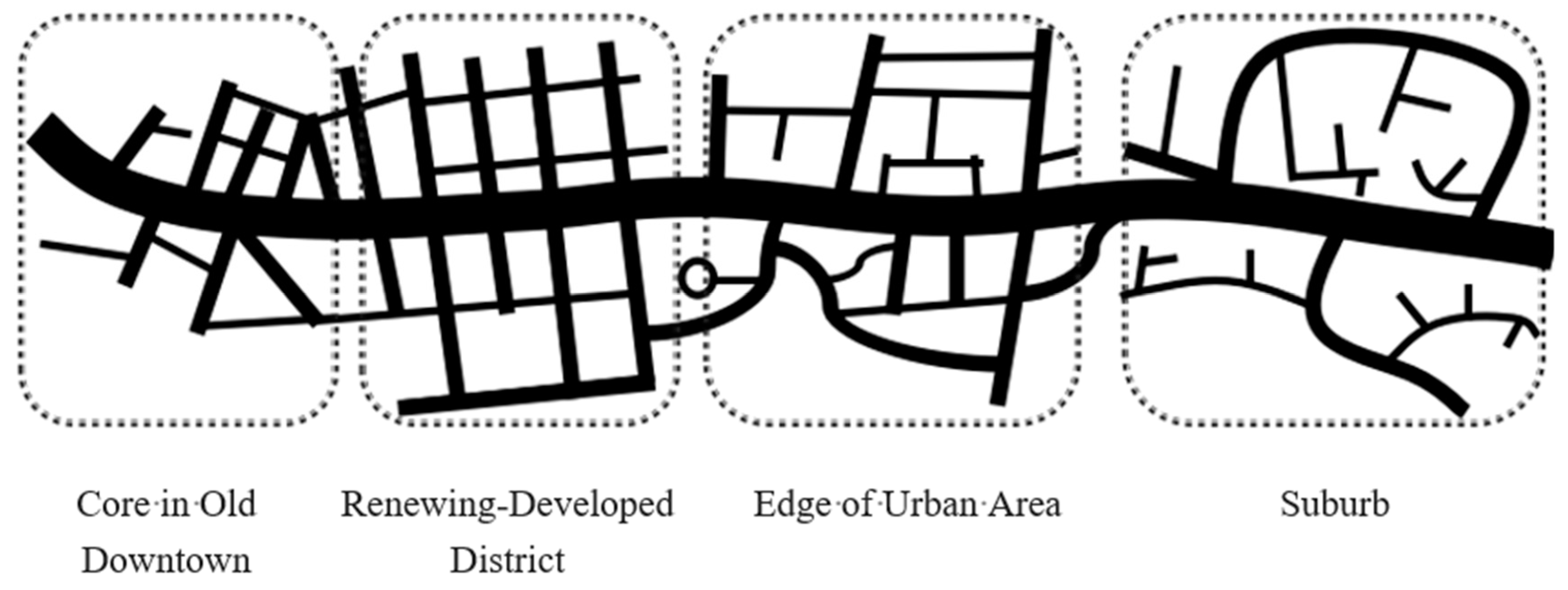
Figure 1 shows how street networks typically change with location, apparently evolving from grid-like to tree-like. The intermediate stages raise several questions. How much does the actual street network at a given stage vary from an ideal grid? Do these irregular-looking networks in fact conform to several basic types? If so, what indicators can be adopted for further division? From Figure 1, the existence of representative street network types in different regions of cities may be inferred, thereby suggesting potential laws governing urban network patterns.
Brindle proposed that there are only two major types of street network structures: the grid network and the tree network, distinguished by the degree of connectivity of the roads [2]. This viewpoint is also the starting point of the present paper. However, this theory does not address the question of how exactly the rest of intermediate networks are different. Due to its strict hierarchical and isolating characteristics, a tree-like network is thought to guarantee pedestrian safety and reduce unwanted through traffic. Although it has been applied in urban planning practice by planning pioneers since the 1930s [3,4], there is still no clear theoretical answer.
In the aspect of urban geometry, Strano et al. [5] divided the European urban road network into different groups by principal component analysis. However, because the research is based on the statistical analysis of the macro urban structure, the results cannot have an impact on small regional land planning. Von and Jaber systematically analyzed the relationship between the structure and texture of urban road network and cultural characteristics in the Middle East, and discussed measures to improve the traditional Arab road network combined with Western ideas [6].
Developing a method to describe the structural differences of networks by planning indicators is also a difficult issue. Traditionally, the indicators adopted in street-network planning have usually been related to the geometry of the network: distance, density, area, etc. However, the values of these indicators for the two kinds of networks may sometimes be very close, even when huge differences exist in patterns and functions.
In recent years, research on street network structure has mainly focused on three aspects: hierarchical structure, connection structure, and layout structure [7]. Hierarchical structure is usually related to the internal composition of the network, which has an important impact on the distribution of traffic flow. Jiang [8] and Buhl et al. [9] have provided new evidence as to how a city network is self-organized for available mobility by using geographic information. Marshall described network forms which fundamental impacted travel behavior, distribution of homes and workplaces, land use, and urban form [10]. Xie and Levinson proposed three new measures, including heterogeneity (entropy), connection pattern, and continuity, specifically examining the structure of urban road networks [11]. Barthelemy and Flammini have shown in their study of street networks that in the absence of a global design strategy, the development of many different transportation networks does follow a simple, general mechanism [12].
The search for a relationship between street network structure and urban land use has become a major research trend [13]. Researching hierarchical and functional structure, Southworth and Ben-Joseph applied spatial syntax theory to analyze the connection and accessibility of street networks [4]. This research was partly successful in interpreting how common people understand the spacious structure of a street network by their experiences. Marshall et al. [14], Southworth et al. [15], and Lovegrove et al. [16] used network density, connectivity, and presence of cul-de-sacs, respectively, as essential indicators for analyzing the connection effect and topological relationships of the network. These results show that street network characteristics do play a role in road safety outcomes. Derrible observed the network complexity and robustness of 33 metro systems around the world [17], and testified that the structure of street networks, therefore, is a result of the interplay between travel cost minimization and efficient land use.
Marshall, Gil et al. used a large amount of data and a variety of analysis methods to study the street network, proposed a network modeling method, and outlined the main street network model features and the complex relationship between different network models [18]. Boeing′s research on the structure of street networks, which calculates the structural indicators of street networks around the world and classifies them into clusters, helped to reveal the scope and nuances of street networks [19]. Shi and Wang believed that the street network structure is not simply a hierarchical, connection, or layout structure, but an organic combination of the three [20]. Porta et al. analyzed the structure and function of urban road network with spatial syntax, which showed that spatial syntax can analyze the in-depth connotation and internal organization of urban road network [21].
In addition, the spatial structure analysis of complex networks has also made important breakthroughs. For example, Mocnik’s research into polynomial volume law verified that the spatial dimension of urban road networks is very stable, but the concentration is quite different [22,23]. These studies have an important reference for later network type identification and network attribute function analysis.
These research results not only show that the road network structure has many variations, but also indicate that the topological parameters of the road network can explain these changes.
2. Methodology
In this paper, we attempted to redefine the tree-like street network and analyze its basic topological features. Based upon several reasonable properties which a street network should possess, we then constructed several basic network patterns, and showed real-world examples of these patterns from various real cities in China and elsewhere. By calculating the topological parameters of each network, a comparative analysis was carried out.
2.1. The Topological Features of the Tree-Like Street Network
In topology, a pure tree-like pattern is called a standard tree graph. By definition, a tree graph is a connected graph that is acyclic (i.e., no sub-graph of the network includes a circle graph). Additional topological characteristics of a tree graph are as follows: (1) Its degree (number of vertices) V is exactly one greater than the number of its edges E; (2) there exists only one path connecting any two separate nodes; and (3) all connected sub-graphs are also tree graphs [24]. In the real world, however, there are almost no tree-shaped networks in the pure topological sense.
In a physical street network, traffic characteristics as well as topology should be taken into account. There are three distinct features that can be used to distinguish between a tree network and a grid-like network:
- (1)
- As is usually obvious by inspection, tree-like street networks have a clearer and more defined hierarchical structure than grids. This condition is necessary for a network to be tree-like; in traffic engineering terms, the artery road runs through the entire area, while the branch road clearly serves a smaller one. A road is only allowed to connect with roads of the same grade or next grade roads. For example, expressway could connect with another expressway or an artery street, but not a local branch.
- (2)
- There exist only a few route switches of different length between any two interior points of a tree-like network. This is an essential difference from the grid street network; it is a necessary and sufficient condition for a network to be a tree network. In most cases, fewer loop routes are found in tree-like street networks. The scarcity of cycles alone, however, is not enough to judge whether a network is tree-like. It is also necessary to confirm if these cycles can provide multipath like a grid network.
- (3)
- There are more T-type intersections and broken roads in the tree-like street system. Undoubtedly, these T-type intersections and broken roads reduce alternative paths for traffic flow, but they provide a more secure environment and the typical appearance characteristics of a tree-like road network.
2.2. Abstracted Expression of Tree-Like Structure in the Street Network
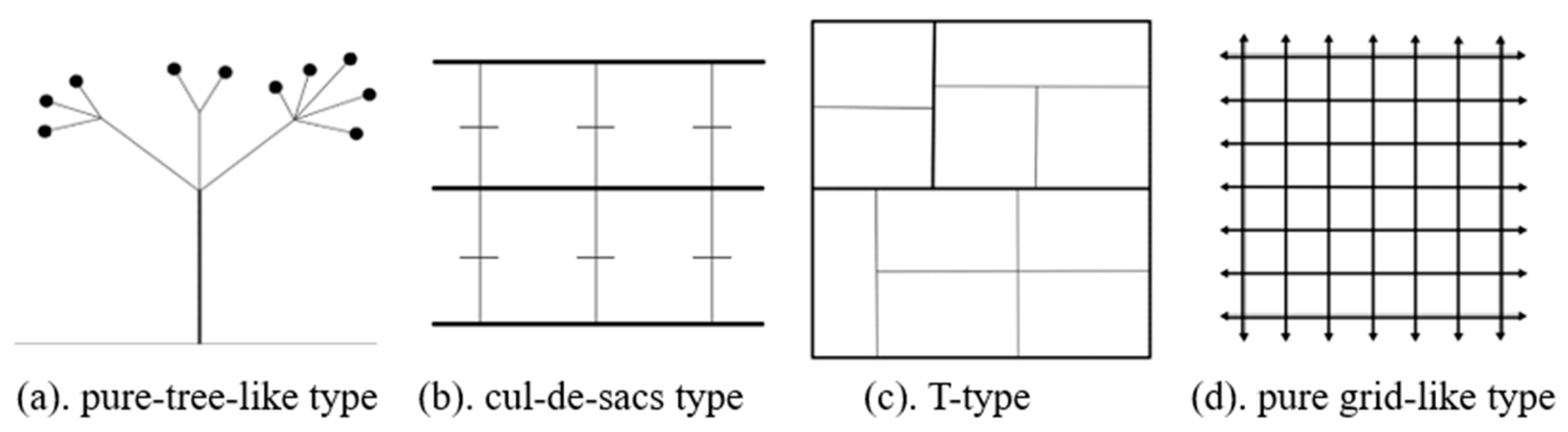
This paper is based on the classification of street networks proposed by Chan et al. [25]. Their research results divided a specific road network model into four basic styles of street network which are laid out in Figure 2 [26]. These patterns, which conform to the real-world design requirements of a street network, can often be observed in cities.
- (1)
- Pure tree-like network pattern (Figure 2a). There are obvious backbone roads through the region, while T-type cross and end-roads are also often adopted, forming a low-connected level network structure. This type of street network helps to protect the privacy of the residents and the stability of the traffic but may be less robust than the others.
- (2)
- The cul-de-sacs network pattern (Figure 2b). There are several trunks passing through a region with many end-roads. This type of network has good accessibility, but might be weaker on interior connectivity than the others.
- (3)
- T-type network pattern (Figure 2c). This street network is similar to a pure grid-shaped network, but the T-type intersections, while possibly reducing the connectivity, may improve the efficiency of trunk transportation.
- (4)
- Pure grid-like network pattern (Figure 2d). The connectivity within this network is higher than in the others; however, due to the excessive number of intersections and the short distance between them, transportation efficiency is usually lower.
The street network system is generally broken into three to five functional classes. The connection between different classes ensures the orderly running of traffic; thus, for example, an arterial road can only can join directly to a sub-arterial street or an expressway, not to local lanes.
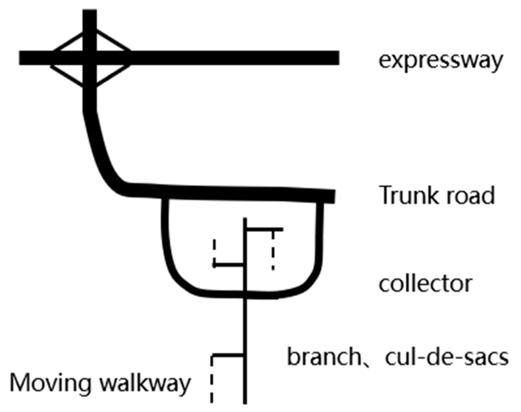
Figure 3 shows a street network constructed according to orderly connecting rules, resulting in a tree-like appearance. This kind of network can often reduce unnecessary through-traffic, guarantee the security of entries and exits of local branches, and even improve the environmental quality and safety situation of the region.
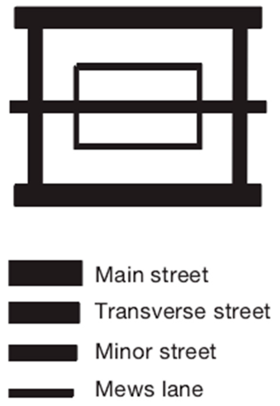
Figure 4represents another special form of street network, consisting of different rectangles. Although this network looks grid-like, it is in general difficult to find multiple roads with similar lengths between any two points within the network. As we have already mentioned, this kind of mono-path is a necessary and sufficient condition for a network to be tree-like. The network conforms to the principle of sequential connection (i.e., even though a circular sub-network exists within the road network), so that while topologically it is not a tree graph, it is nevertheless a tree network.
2.3. Differences between the Basic Patterns of the Road Network
The traditional indicators for describing the rationality of a road network, such as density, grade, and length, are largely concerned with size and appearance. However, they do not well reflect the difference between the internal relationships and the composition of the street networks. According to the research of Marshall, the T-type ratio can effectively distinguish the pure tree-like street network from other kinds [10], but the problem of dividing mixed networks into different types on a spectrum from pure tree-like to pure grid-like remains difficult.
In Figure 2, the main difference between (a) and (b) is whether there are multiple major roads running through the region. The most significant difference between (b) and (c) is whether there exist end-roads. The difference between (c) and (d) is whether there exist T-type intersections. Based on this analysis, it should be feasible to determine the type of street network by considering the relative prevalence of through roads, cul-de-sacs, and T-type intersections. Combined with previous research results [2,4], the penetrating street ratio, cell ratio, and T-type ratio are introduced for network division.
3. Parameters Describing the Network Pattern
3.1. T-Type and X-Type Intersection Ratios
The T-type and X-type ratios are the ratios of the number of T-type and four-leg intersections, respectively, to all intersections in a given area. If T-type and X-type intersections are the only ones that appear in a region, the T-type and X-type ratios of the street network add up to 1. These ratios can very easily be found by simple counting.
3.2. Penetrating Street Ratio
A penetrating street (run-through road) is one that completely crosses an area of interest. The penetrating street ratio is the ratio of the number of run-through roads to the total number of roads in a specific area. This index directly reflects the number and proportion of trunk roads in the network, and the opening level of the region. As the value of this indicator becomes lower, the street network comes closer to having a tree-like structure.
3.3. Cul-De-Sac and Cell Ratios
There are two types of road segments in a street network: cul-de-sacs (end streets) and ordinary road segments (cells, i.e., stretches of road between intersections). The cul-de-sac and cell ratios of a street network are the ratios of the number of end roads and cells, respectively, to the sum of all road sections in a region. In general, the sum of the cell ratio and the cul-de-sac ratio in a single network is 1. In a pure grid-like street network, there are no end roads, so the cul-de-sac ratio is 0 and the cell ratio is 1. In a real street network layout, the cul-de-sac and cell ratios of the street network both lie between 0 and 1.
4. Sample Analysis
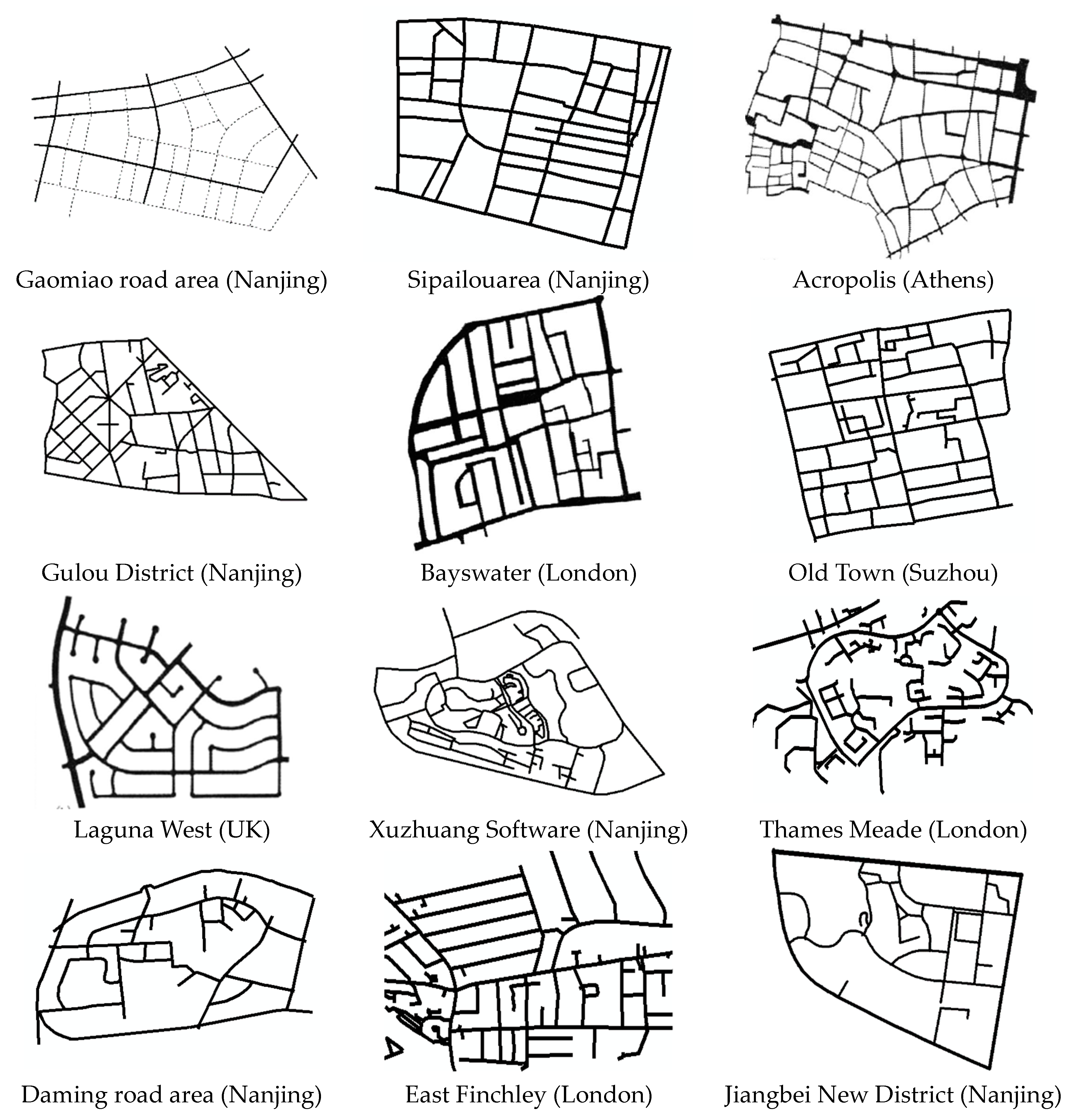
To analyze whether street network types in different regions have any identifiable differences, this study selected 15 urban street networks from around the world, having different shapes and characteristics, as samples.
The number of 15 samples seems to be small, but considering the following reasons, this study considers that these samples show the reliability of the research objectives and results. Although the appearance of the city varies greatly, according to the analysis of Section 2.2., the main pattern differences of the urban road network lie in the form of intersections and the density of the road network. As a classification study, it is only necessary to find out the characteristics of the reference point or the reference network, and it is not necessary to identify all the networks one by one. In fact, relying too much on large-scale statistical data may not be able to accurately identify road network features, because some features may be submerged in the massive statistical values. In addition, about 30 road network samples were preliminarily selected in this study. In order to express the road network boundary and data distribution clearly, the city samples with similar or repeated patterns and parameters were removed.
By extracting the values of basic attributes from map, such as road-section length, grade, type, and rank of intersections, several indexes of topological structure were evaluated, and then analyzed by ArcGIS software to compare with each other.
4.1. Principles of Sample Selection
- (1)
- Most of the street network samples come from historic Chinese cities, such as Nanjing and Suzhou. Others were taken from a classic scholarly work on streets and patterns [2].
- (2)
- The samples represent different parts of urban areas: new development zones, cores of downtown districts, ring areas around the city, and outer suburban residential areas.
- (3)
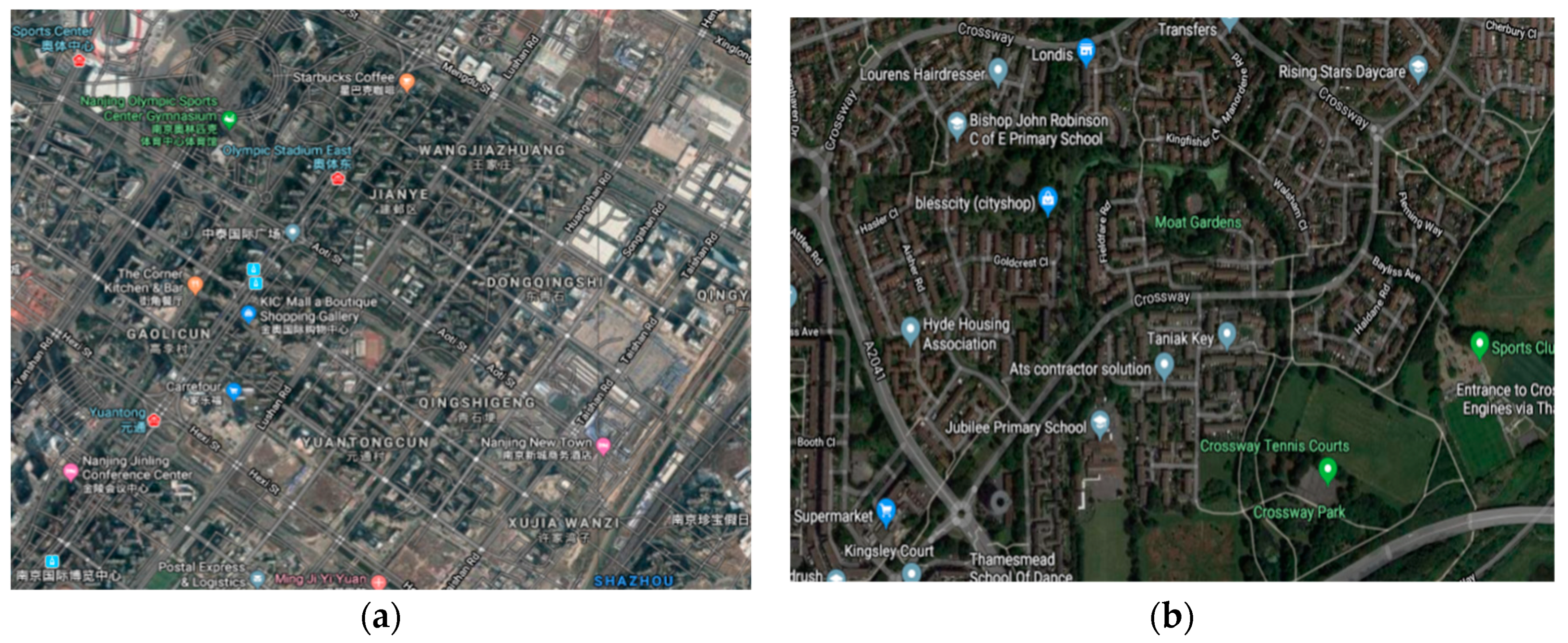
- For convenience of comparison, each sample’s area was limited to four square kilometers (2 km × 2 km). Considering the influence of ground facilities or terrain features, such as railways and rivers, an irregular boundary was also acceptable when the sample had an obvious shape feature. Figure 5 shows two different examples of urban areas from the sample set.
4.2. Data Collection and Analysis
The data source collection in this paper mainly used OpenStreetMap and ArcGIS to screen, extract, construct, correct, analyze, and abstract street network maps in urban core areas, urban areas, and communities. OpenStreetMap is a global collaborative mapping project that can provide its spatial data through various APIs (Application Programming Interface: are some predefined functions to provide applications and developers with the ability to access a set of routines based on certain software or hardware, but No need to access the source code or understand the details of the internal working mechanism). This database resource is very reliable.The method was simply to collect and screen street network examples, extract street network samples from OpenStreetMap, export OpenStreetMap files, use Geo Converter software to convert them to ESRI Shapefiles, modify the wrong paths in ArcGIS software, and obtain the relevant attributes of each road segment in the sample network. When processing the road network, the edge path of each geometry was buffered by 0.1 km in order to collect the “node types” and “paths” in the road network.
The 15 street network samples may be seen in Figure 6. The samples can be divided into the four basic pattern types mentioned previously (2.2): standard rectangular grid, T-type, cul-de-sac based, and pure tree-like (see Table 1).
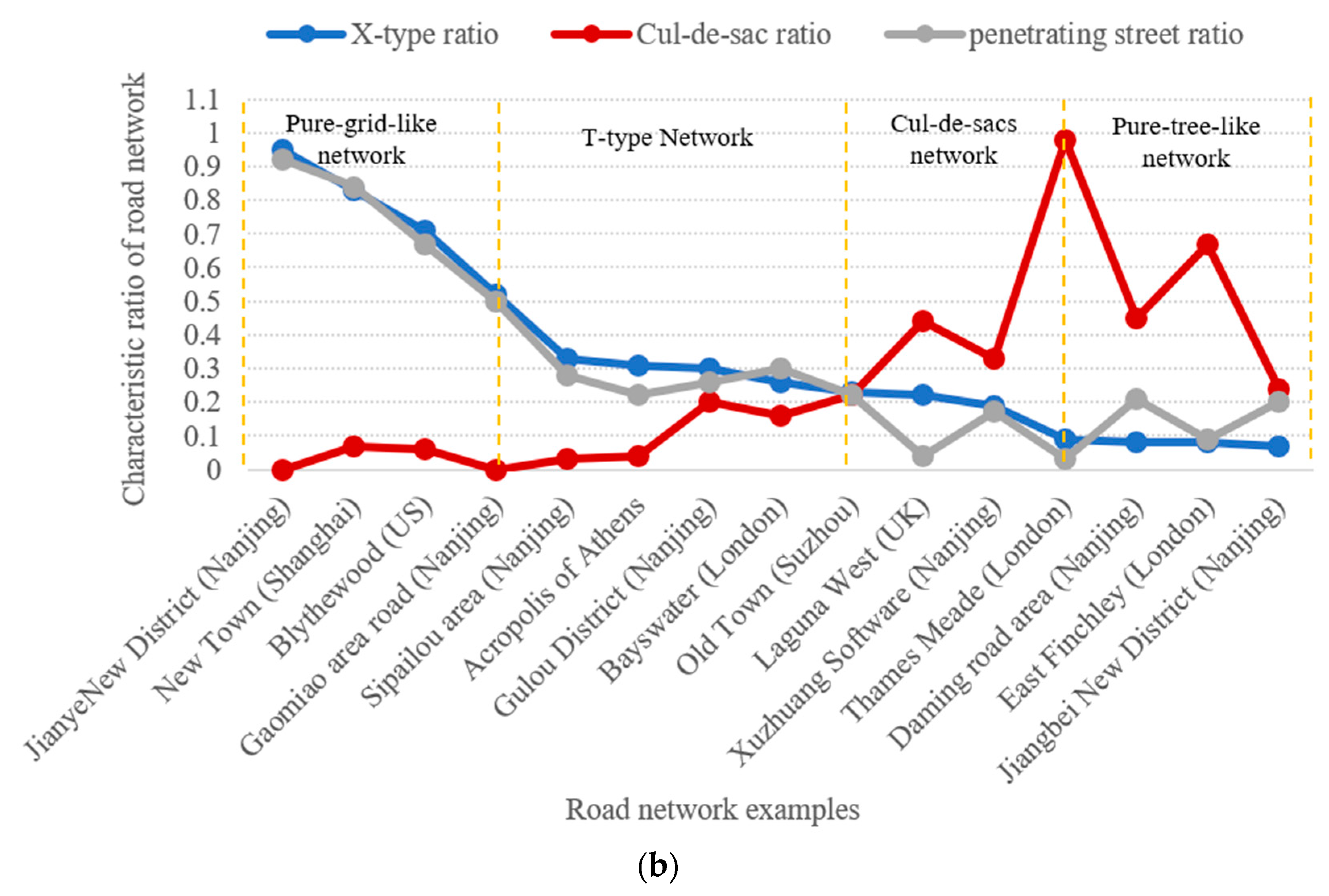
The four sample indicators (X-type ratio, T-type ratio, cul-de-sac ratio, and penetrating street ratio) were calculated, and are also marked in Table 1. It can be seen that the X-type and T-type ratios were well correlated with pattern type. However, the penetrating street ratio was loosely correlated with the X-type and T-type ratios. Therefore, the X-type and T-type ratio were selected as the first factor to identify the tree-like attributes of the road network.
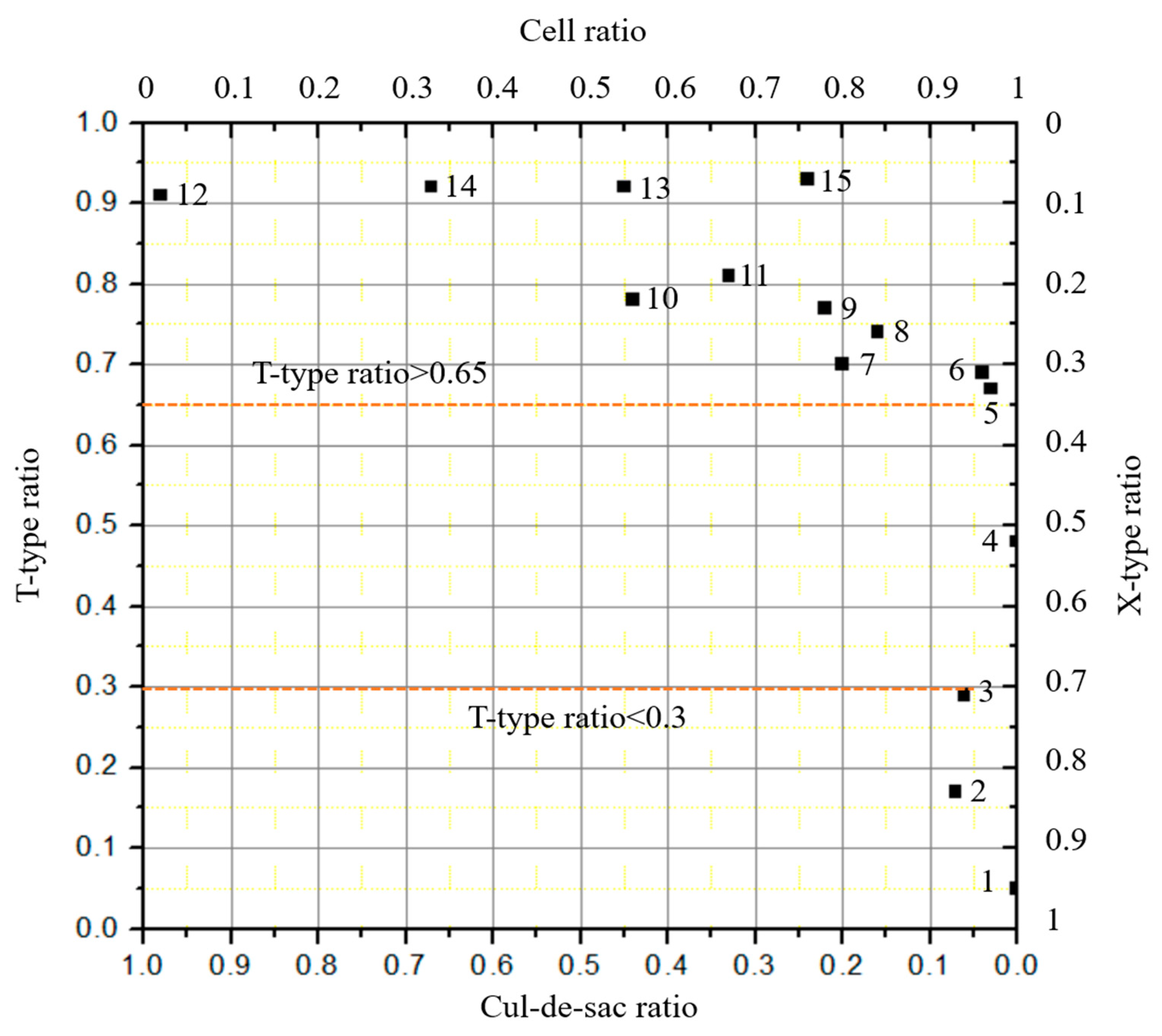
The cul-de-sac ratio, on the other hand, did not correlate well with the pattern type. Figure 7 shows the relationship of T-type ratio and cul-de-sac ratio for all the samples.
From Figure 7, the T-type ratio is seen to be higher than 0.65 in most sample cities. This indicates that most urban street networks contained a large number of T-intersections. On the other hand, the cul-de-sac ratio of most samples was lower than 0.3.
4.3. Data Analysis and Interpretation
The above results shown that the variations of the indicators (the penetrating street, T-type, X-type, and cul-de-sac ratios) could be used to judge a given street network’s structural subtype.
- From Figure 8a, it is obvious that, when the samples are listed in order of monotonically increasing T-type ratio, three distinct regimes emerge, namely T-type ratio ∈ [0,0.3), [0.3,0.9), [0.9,1.0]. These three parts respectively correspond to a pure grid-like network, a transitional state network, and a pure tree-like network. This method can clearly define the boundary between pure tree- and pure grid-like road networks. However, because the indicator values in the transitional region are very close together, it is hard to distinguish any finer divisions in that regime.
- It can be seen from Figure 8b that the penetrating street ratio and the X-type ratio are highly coincident and have almost the same general tendencies in the figure. When the value of either is more than 0.3, it can be used to distinguish a pure grid road network from a rectangular-type street network. However, when the value is less than 0.3, a pure tree-like road network and a T-shaped road network cannot be accurately identified from these indicators alone.
- From Figure 8b, the trend of the cul-de-sac ratio seems to be nearly opposite that of the X-type ratio, but it might be more active (i.e., have more discriminating power) when it is close to the area of the tree-like network pattern. When the cul-de-sac ratio ∈ [0,0.3), the network could be predicted to be either grid-shaped or T-type. When the cul-de-sac ratio ∈ [0.3,0.5), the network could be of the cul-de-sacs type. Finally, when the cul-de-sacs ratio ∈ [0.5,1.0], the network might be purely tree-like.
- The penetrating street ratio is an important and effective indicator for objectively measuring the similarity of a general network to a tree-like network. It has not received enough attention in previous analyses.
5. Conclusions and Further Research
This paper tries to answer the most basic question about the geometric structure of urban road networks: how to distinguish between road networks with different geometric forms.
From a topological perspective, both in terms of hierarchical connections and pattern features, the tree-like characteristics concealed in a road network can now be recognized, opening another way to understand the road system besides the traditional grid paradigm.
- (1)
- The main point of this paper is to recognize that all urban road networks, instead of being classified as grids or trees, may be arranged on a spectrum between these extremes. Subdividing the geometric structure of the road network further can be effective for research and engineering technology, improvements in land use, road safety, and transportation efficiency in the future.
- (2)
- Through statistical analysis of road samples in different cities or regions, it has been found that the differences in geometric and topological characteristics between the networks mainly come from the number and the type of intersections, the density and hierarchical structure of the road networks, the proportion of broken roads, and the number and proportion of through-roads. Therefore, a road network can be classified according to how closely it resembles a tree-like network in terms of these various parameters.
- (3)
- This study initially divides road networks into four types (pure tree-like networks, cul-de-sac networks, T-shaped networks, and grid-shaped networks) based on properties such as non-circular traffic, number of end roads, and number of alternative paths.
- (4)
- The research proves that it is possible to use different indicators in a certain order (X-type/T-type ratio, cul-de-sac ratio, and penetrating street ratio) to classify road networks. Four specific, quantitative, well-defined indicators for classifying the small-scale structure of street networks are proposed.
Although the study has found some evidence of pattern differences between networks, some defects existed in the research procedure. The largest problem is that it is difficult to collect attributed data, such as the class of road or the features of the nodes, from the e-map; this may reduce accuracy when analyzing the connectivity of local roads, especially for topological analysis.
Secondly, this study also partly neglected road link attributes, street function, accessibility, and other factors that may further reflect the structure of the street network in some way. On the other hand, adding more indicators would very likely increase the difficulty of the research and the uncertainty of the results.
Additionally, it is found that when different observation scales are used, the indicator value may change, owing to data filtering or boundary effects. This is of great significance for the fractal characteristics of the network, which are another important method of judging the hierarchy and self-similarity of the street system.
On the whole, a tree-like network reflects the basic characteristics of a transportation network better than a grid-like network. Indeed, a grid-like road network can be transformed into a tree-like one by restricting the direction of traffic flow.
Subsequent research on the road network form should not be limited to geometric parameters; the spatial layout of the traffic flow lines should also be considered. Having distinguished the different types of networks, the next step is to analyze the differences in traffic and land use benefits between different micropatterns. This research will promote technological compatibility and coordination between street network and other land use.
Author Contributions
Conceptualization, B.H.; methodology, B.H. and D.S.; software, L.D.; validation, X.Y. and D.S.; formal analysis, X.Y. and D.S.; investigation, W.S. and L.D.; resources, L.D.; data curation, W.S.; writing—original draft preparation, X.Y. and W.S.; writing—review and editing, B.H. and D.S. All authors have read and agreed to the published version of the manuscript.
Funding
This research was funded by the Science and Technology Project of the Ministry of Housing and Construction (MHC) of China, grant number (2017-k2-008, to Han BR) and The APC was funded by China Scholarship Council (CSC) funding, grant number (201808320054, to Han BR).
Acknowledgments
We thank Zhou Yu for the technical assistance with software analysis. He LL collected the examples of documentaries.
Conflicts of Interest
The authors declare no conflict of interest. The funders had no role in the design of the study; in the collection, analyses, or interpretation of data; in the writing of the manuscript, or in the decision to publish the results.
References
- Boeing, G. A multi-scale analysis of 27,000 urban street networks: Every US city, town, urbanized area, and Zillow neighborhood. Environ. Plan. B Urban Anal. City Sci. 2018, 8, 1–19. [Google Scholar] [CrossRef] [Green Version]
- Brindle, R.E. Road Hierarchy and Functional Classification. Spec. Rep. 1996, 53, 99–109. [Google Scholar]
- Ye, P.Y.; Chen, X.H. Reviews of Radburn Idea’s Road and Traffic Planning. Urban Plan. Int. 2009, 24, 69–73. [Google Scholar]
- Southworth, M.; Eran, B.J. Streets and the Shaping of Towns and Cities, 2nd ed.; Island Press: Washington, DC, USA, 2003; ISBN 1-55963-916-4. [Google Scholar]
- Strano, E.; Luciano da Fontoura Costa, M.V.; Cardillo, A.; Porta, S.; Latora, V. Urban street networks, a comparative analysis of ten European cities. Environ. Plan. B Plan. Des. 2013, 40, 1071–1086. [Google Scholar] [CrossRef] [Green Version]
- Von, V.; Jaber, S. Urban Streets: Towards Sustainable Mobility in Arabic Cities; University at Stuttgart: Stuttgart, Germany, 2013. [Google Scholar] [CrossRef]
- Cai, J. Urban Road Network System Planning; China Construction Industry Press: Beijing, China, 2013; ISBN 978-7-112-15824-9. [Google Scholar]
- Jiang, B. Street Hierarchies: A Minority of Streets Account for a Majority of Traffic Flow. Int. J. Geogr. Inf. Sci. 2009, 23, 1033–1048. [Google Scholar] [CrossRef]
- Buhl, J.; Gautrais, J.; Reeves, N.; Sole, R.V.; Valverde, S.; Kuntz, P.; Theraulaz, G. Topological Patterns in Street Networks of Self-Organized Urban Settlements. Eur. Phys. J. 2006, 49, 513–522. [Google Scholar] [CrossRef]
- Marshall, S. Streets & Patterns, 1st ed.; China Architecture & Building Press: Beijing, China, 2011; pp. 35–37. ISBN 978-7-112-12724-5. [Google Scholar]
- Xie, F.; Levinson, D. Measuring the structure of road networks. Geogr. Anal. 2007, 39, 336–356. [Google Scholar] [CrossRef]
- Barthelemy, M.; Flammini, A. Modeling Urban Street Patterns. Phys. Rev. Lett. 2008, 4, 1–4. [Google Scholar] [CrossRef] [PubMed] [Green Version]
- Sreelekha, M.G.; Krishnamurthy, K.; Anjaneyulu, M.V.L.R.C. Interaction between Road Network Connectivity and Spatial Pattern. Procedia Technol. 2016, 24, 131–139. [Google Scholar] [CrossRef] [Green Version]
- Marshall, W.E.; Lennard, H.L. Street Network Types and Road Safety: A Study of 24 California Cities. Urban Des. Int. 2010, 15, 133–147. [Google Scholar] [CrossRef]
- Southworth, M.; Ben-Joseph, E. Reconsidering the Cul -de-sac. ACCESS Mag. 2004, 1, 28–33. [Google Scholar]
- Lovegrove, G.R.; Sun, J. Using Community-Based Macro level Collision Prediction Models to Evaluate Safety Level of Neighborhood Road Network Patterns. In Proceedings of the 89th Annual Meeting of the Transportation Research Board, Washington, DC, USA, 10–14 January 2010. [Google Scholar]
- Derrible, S.; Kennedy, C. The Complexity and Robustness of Metro Networks. Phys. A-Stat. Mech. Its Appl. 2010, 389, 3678–3691. [Google Scholar] [CrossRef]
- Marshall, S.; Gil, J.; Kropf, K.; Tomko, M.; Figueiredo, L. Street Network Studies: From Networks to Models and their Representations. Netw. Spat. Econ. 2018, 18, 735–749. [Google Scholar] [CrossRef] [Green Version]
- Boeing, G. Urban spatial order: Street network orientation, configuration, and entropy. Boeing Appl. Netw. Sci. 2019, 4, 67. [Google Scholar] [CrossRef] [Green Version]
- Shi, F.; Wang, W. Urban Road Network Structure Analysis. City Plan. Rev. 2007, 31, 68–73. [Google Scholar]
- Porta, S.; Crucitti, P. The network analysis of urban streets: A primal approach. Environ. Plan. B Plan. Des. 2006, 33, 705–725. [Google Scholar] [CrossRef] [Green Version]
- Mocnik, F.B. The Polynomial Volume Law of Complex Networks in the Context of Local and Global Optimization. Sci. Rep. 2018. [Google Scholar] [CrossRef] [PubMed]
- Mocnik, F.B. Dimension as an Invariant of Street Networks. In Proceedings of the 7th International Conference on Complex Networks and Their Applications, Cambridge, UK, 11–13 December 2018; pp. 455–457. [Google Scholar]
- Tian, F.; Zhang, Y.Q. Graph. and Network Flow Theory, 2nd ed.; Science Press: Beijing, China, 2015; pp. 47–50. ISBN 978-7-03-042688-8. [Google Scholar]
- Chan, S.H.Y.; Donner, R.V.; Lämmer, S. Urban road networks-spatial networks with universal geometric features? Eur. Phys. J. B 2011, 84, 563–578. [Google Scholar] [CrossRef] [Green Version]
- Lima, M. The Book of Trees: Visualizing Branches of Knowledge; China Machine Press: Beijing, China, 2015; pp. 5–9. ISBN 978-7-111-51518-0. [Google Scholar]
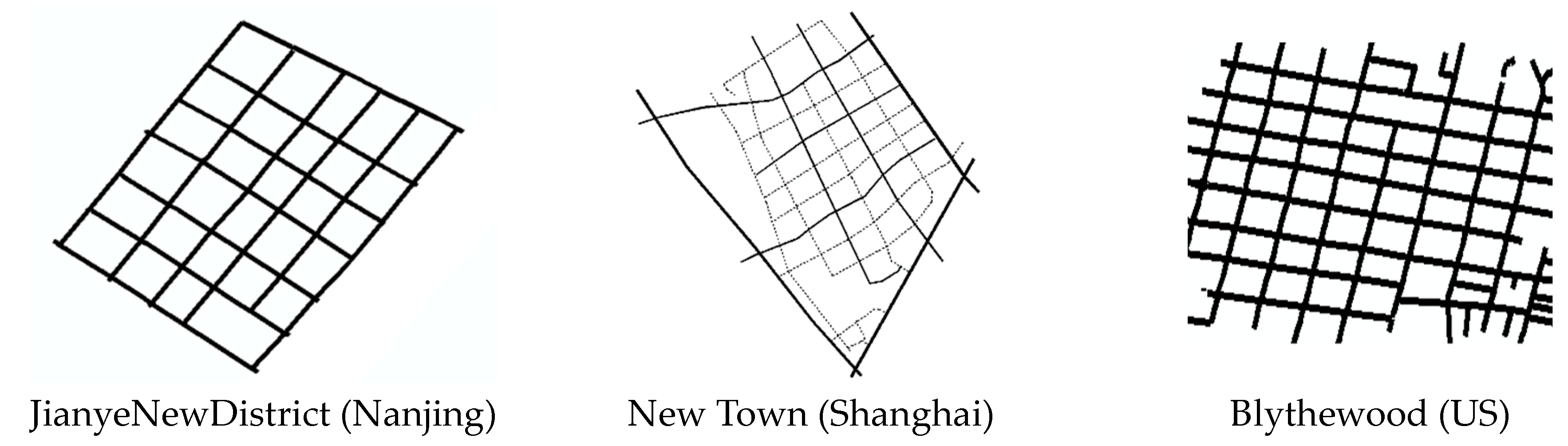
Figure 1.
Four representative street network types in different regions of a city.

Figure 2.
Abstract structures of four kinds of urban street networks.

Figure 3.
Typical tree-like street network structure.

Figure 4.
Rectangle structure forming a tree-like street network.

Figure 5.
Typical street network samples. (a) Typical gird network (Nanjing); (b) Typical tree0like network (London Thames).
Figure 5.
Typical street network samples. (a) Typical gird network (Nanjing); (b) Typical tree0like network (London Thames).

Figure 6.
Street network diagram of 15 samples.


Figure 7.
Distribution of topological indexes of different road network samples.

Figure 8.
Relations between urban street network types and indicators. (a) Cities arranged by increasing T-type ratio. (b) The variation of X-type ratio, cul-de-sac ratio, and penetrating street ratio with street network types.
Figure 8.
Relations between urban street network types and indicators. (a) Cities arranged by increasing T-type ratio. (b) The variation of X-type ratio, cul-de-sac ratio, and penetrating street ratio with street network types.


Table 1.
Parameter values of sample cities.
| Serial Number | Network Location | X-Type Ratio | T-TypeRatio | Cul-de-Sac Ratio | Penetrating Street Ratio | Types of Image |
|---|---|---|---|---|---|---|
| 1 | JianyeNewDistrict (Nanjing) | 0.95 | 0.05 | 0 | 0.92 | A |
| 2 | New Town (Shanghai) | 0.83 | 0.17 | 0.07 | 0.84 | A |
| 3 | Blythewood (US) | 0.71 | 0.29 | 0.06 | 0.67 | A |
| 4 | Gaomiao area (Nanjing) | 0.52 | 0.48 | 0 | 0.50 | B |
| 5 | Sipailouarea (Nanjing) | 0.33 | 0.67 | 0.03 | 0.28 | B |
| 6 | Acropolis (Athens) | 0.31 | 0.69 | 0.04 | 0.22 | B |
| 7 | GulouDistrict (Nanjing) | 0.30 | 0.70 | 0.2 | 0.26 | B |
| 8 | Bayswater (London) | 0.26 | 0.74 | 0.16 | 0.30 | B |
| 9 | Old Town (Suzhou) | 0.23 | 0.77 | 0.22 | 0.22 | B |
| 10 | Laguna West (UK) | 0.22 | 0.78 | 0.44 | 0.04 | C |
| 11 | XuzhuangSoftware (Nanjing) | 0.19 | 0.81 | 0.33 | 0.17 | C |
| 12 | Thames Meade (London) | 0.09 | 0.91 | 0.98 | 0.03 | C/D |
| 13 | Daming road area (Nanjing) | 0.08 | 0.92 | 0.45 | 0.21 | D |
| 14 | East Finchley (London) | 0.08 | 0.92 | 0.67 | 0.09 | D |
| 15 | Jiangbei New District (Nanjing) | 0.07 | 0.93 | 0.24 | 0.20 | D |
Notes: The road network instances in the table are sorted by type. The types are (A) Pure grid-like network pattern, (B) T-type network pattern, (C) cul-de-sac network pattern and (D) pure tree-like network pattern.
© 2020 by the authors. Licensee MDPI, Basel, Switzerland. This article is an open access article distributed under the terms and conditions of the Creative Commons Attribution (CC BY) license (http://creativecommons.org/licenses/by/4.0/).
Share and Cite
MDPI and ACS Style
Han, B.; Sun, D.; Yu, X.; Song, W.; Ding, L. Classification of Urban Street Networks Based on Tree-Like Network Features. Sustainability 2020, 12, 628. https://0-doi-org.brum.beds.ac.uk/10.3390/su12020628
AMA Style
Han B, Sun D, Yu X, Song W, Ding L. Classification of Urban Street Networks Based on Tree-Like Network Features. Sustainability. 2020; 12(2):628. https://0-doi-org.brum.beds.ac.uk/10.3390/su12020628
Chicago/Turabian StyleHan, Baorui, Dazhi Sun, Xiaomei Yu, Wanlu Song, and Lisha Ding. 2020. "Classification of Urban Street Networks Based on Tree-Like Network Features" Sustainability 12, no. 2: 628. https://0-doi-org.brum.beds.ac.uk/10.3390/su12020628
Note that from the first issue of 2016, this journal uses article numbers instead of page numbers. See further details here.